Back to Documents

Planning Commission Agenda

PDF Planning Commission Sep 23, 2025 at 07:00 PM Processed: Sep 16, 2025 at 08:58 PM

PDF Content

Pages: 43

Planning Commission Special Called Meeting http://www.roswellgov.com/ ~Agenda~ Chair Kitty Singleton Vice Chair Eric Schumacher Commissioner Jason Frazier Commissioner Pooja Gardner Commissioner Charles Krieger Commissioner Gurtej Narang Commissioner Carol Williams Tuesday, September 23, 2025 7:00 PM City Hall - Council Chambers \ Possible Quorum of Mayor and City Council \* Welcome - I. Call to Order - II. Agenda Item - 1. 20253972 - Hill Street Mixed-Use Development - Preliminary Plat - III. Minutes - 2. July 21, 2025 PC Special Called Meeting Minutes IV. Adjournment**
City of Roswell Planning Commission Special Called AGENDA ITEM REPORT ID # - 10063 MEETING DATE: September 23, 2025 DEPARTMENT: Planning Commission ITEM TYPE: Plat 20253972 - Hill Street Mixed-Use Development - Preliminary Plat Item Summary: Enclosed, please find the preliminary plat of the Hill Street Overlay District, Area A. The area consists of 6.4 acres. It is zoned DX (Downtown Mixed Use), CIV (Civic) and HSOD (Hill Street Overlay District). Committee or Staff Recommendation: Staff recommends approval with conditions of this plat. Financial Impact: N/A Recommended Motion: Motion to recommend approval with conditions for the Hill Street Overlay District, Area A preliminary plat. Presented by: Angela Rambeau
- To: Planning Commission - From: Angela Rambeau, Planner 3 Date: 9/15/2025 Subject: Hill Street Overlay District, Area A Preliminary Plat Property Addresses: Address Parcel # Acres 839 Atlanta Street 12 -7 0.418 833 Atlanta Street 12 -5 0.322 25 Hill Street 12 -2 0.581 39 Hill Street 12 -0 3.27 820 Community Circle 12 -8 0.45 808 Community Circle 12 -6 0.4 800 Community Circle 12 -3 0.315 897 Oak Street 12 -9 0.663 Enclosed, please find the preliminary plat review for the Hill Street Overlay District, Area A. The area consists of 6.4 acres. It is zoned DX (Downton Mixed Use), CIV (Civic) and HSOD (Hill Street Overlay District). The property is bounded by Atlanta Street, Hill Street and Ellis Street and is located in the historic district. Staff Recommendations The preliminary plat for Hill Street has been approved with conditions by all city departments. All conditions must be addressed either prior to the recording of the final plat or prior to the issuance of land development permit (LDP). The Zoning Director's certification that the preliminary final plat complies with all applicable requirements of the UDC is included in the attachments. The following are the conditions of the final plat approval and are to be included either on the final plat for recording and/or on the Land Development Permit plans. - 1. The dimensions of all easements shall be indicated on the final plat prior to recording. - 2. All utilities should be shown in an easement. These shall be shown on the Land Development Permit.
- 3. The centerline of existing and proposed pavement shall be labeled on the Land Development Permit. - 4. The provision for sewage disposal shall be provided on the final plat prior to recording. - 5. The stormwater table indicating the existing and proposed impervious area square footage for each lot shall be included on the final plat prior to recording. - 6. The intersection pavement, ROW radius, all centerline curve data and tangent data shall be included on the final plat prior to recording. - 7. The Flood Note has been updated to show FEMA community number 130088, but the City's required Flood Note should provide the community panel number, which is 13121C0063G. This shall be updated prior to the recording of the final plat. - 8. Update the scale in the title block on sheets 1,2, and 3 prior to the recording of the final plat. - 9. Fulton County Health signature must be obtained prior to the recording of the final plat. The following are conditions of the LDP approval: - 1. All fees for the removal of specimen trees shall be determined during the Land Development Permit process and payment is required prior to the issuance of the Land Development Permit. - 2. Locate the backflow vault past the meter vault and show connections of the 6" fire line that is to feed the townhomes on the LDP and final plat prior to recording. - 3. Provide the location of existing 8" waterline that runs along Ellis Street on the LDP and final plat prior to recording. - 4. Provide the 8" water line from its connection on Oak Street to Community Circle on the LDP and final plat prior to recording. - 5. Provide and show connection of the two vaults and the backflow vaults to the multifamily buildings that the line will serve on the LDP and final plat prior to recording. - 6. Show tie-in of the two vaults to the 8" public water line on the LDP and final plat prior to recording. - 7. Provide a utility easement for the meter vault from the back of the right-of-way all around the vault. This easement shall be shown on the LDP and final plat prior to recording. - 8. Provide a meter and backflow for the 2" line feeding the parking deck on the LDP and final plat prior to recording as long as the 8" line on Community Circle is to remain as a part of the public water system. - 9. Provide and show the connection for the meter vault to the public water system that is located at the corner of Hill Street and Ellis Street. Show this connection on the LDP and final plat prior to recording.
- 10. Provide the location of all valves where the vaults connect to the public water system on the LDP and final plat prior to recording. - 11. A valve and plug shall be added to the end of the 12" line for the future connection point. This shall be included on the Land Development Permit plans and final plat prior to recording. - 12. Note number 12 shall be deleted and replaced with the following " All Sidewalks on all street frontages shall be maintained by the developer". This note shall be added to the LDP and final plat prior to recording. - 13. On the LDP plans, please either meander the sidewalk around the fire hydrant that is shown along the Atlanta Street/SR 9 trail or relocate it. - 14. All utilities shall be identified either by called out or in a legend on the Land Development Permit plans. - 15. Indicate all abandoned driveways and ADA ramps shall be closed with streetscape that is to match the streetscape along that street whether it is curb and gutter, grass strip, trail or sidewalk. These items shall be indicated on the Land Development Permit plans. - 16. All private streets shall meet public street standards. Please show the Land Development Permit plans. - 17. All road profiles shall be updated and completed (profile slope, tangent lines are connected by curve, and k-values) are all shown on the Land Development Plans. - 18. The pipe along Ellis Street in close proximity to TH #4 must be relocated 10 ft from the foundation edge of the building, if this is not a possible option, a structural engineer or geotechnical engineer must certify the placement of the pipe in close proximity will not impact the structural integrity of the building foundation. This must be completed prior to the issuance of the Land Development Permit. - 19. That same pipe must be located 10' from the ROW, the dedication of an easement in the ROW will not work for the stormwater division, lesser clearance could be approved upon agreement with EPW stormwater Division staff. This must be completed prior to the issuance of the Land Development Permit. - 20. The 10 ft easement from the ROW line along Hill Street must be met around the Under Ground detention. The recommendation is to eliminate one leg of pipe and extend the other leg longer along Hill Street and move the pipe inwards to satisfy that requirement. This must be completed prior to the issuance of a Land Development Permit.
Advisory Comments: - 1. The Land Development Permit must be displayed & visible from the street curb. Permits & plans bearing the stamp of the City of Roswell Building Division must be onsite during the entire duration of the job. They must be kept in an accessible weatherproof device or area. Inspections will not be performed if permits and stamped plans are not legible and accessible to the inspector. - 2. The permit must be displayed & visible from the street curb. Permits & plans bearing the stamp of the City of Roswell Building Division must be on-site during the entire duration of the job. They must be kept in an accessible weather-proof device or area. Inspections will not be performed if permits and stamped plans are not legible and accessible to the inspector. - 3. Access for requested inspection is required between the hours of 8AM until 4PM without exception. Please be aware that the City of Roswell must formally review any proposed changes or modifications to the approved plans before implementation is authorized. - 4. Private inspections are not allowed in lieu of City of Roswell inspections. The City of Roswell Building Department may require special inspections or engineering inspections in addition to City inspections. - 5. The Roswell Fire Marshal's Office has reviewed the submitted plans and specifications in strict adherence to the prevailing state-adopted minimum Fire Safety Standards at the time of evaluation. Every possible effort has been invested to ensure thorough scrutiny for code compliance. However, it is essential to emphasize that this comprehensive review does not absolve the owner, contractor, architect, or any other accountable party from their obligation to comply with any aspects inadvertently overlooked or undisclosed by the reviewer. - 6. Please be aware that the City of Roswell must formally review any proposed changes or modifications to the approved plans before implementation is authorized. - 7. A preliminary plat will be required forthe townhouse parcel when subdivided to separate each of the units. At that time, the final plat will be required to show the minimum dimensional requirements for the townhomes as approved by Mayor and Council.
Plan Review Comments Planning And Zoning, Angela Rambeau App W/Cond - 09/12/2025 Reviewer: Angela Rambeau, Planner III, 6413, arambeau@roswellgov.com. These comments will be met by the language in the conditions of approval. Show dimensions of easements. Some parts of utility lines are not included in the dotted areas. Label centerline of existing and proposed pavement. Note provision for sewage disposal. Provide stormwater table indicating the existing or proposed impervious area square footage for each lot. Minimum primary street frontage/minimum lot width should be TBD by MCC. Show intersection pavement and ROW radius, all centerline curve date and tangent data. Engineering Division, Lee Smith App W/Cond - 09/11/2025 Reviewer: Lee Smith, 6889, lsmith@roswellgov.com These comments will be met by the language in the conditions of approval. 1) Sheets 1, 2 and 3 � Scale is called out in the title block incorrectly. In the version of this document that is provided for recordation, correct or remove the scale in the title block on these sheets. 2) Sheet 1 � The Flood Note has been updated to show FEMA community number 130088, but the City�s required Flood Note should provide the community panel number, which is 13121C0063G. Correct this note for recordation by providing the community panel number. 3) Sheet 4 � The revised sheet appears to show proposed meter vaults and backflow preventers that are not connected to the water distribution system. In the plat provided for recordation, be sure to show only existing features on the existing conditions sheet. These comments will be met by the language in the conditions of approval. The fees for the removal of the specimen trees will be paid at the time of the LDP process - prior to issuance of the LDP. Transportation, Mark Dana App W/Cond - 09/15/2025 Reviewer: Serge Osse - 6428(direct) 6420(Main) sosse@roswellgov.com These comments will be met by the language in the conditions of approval. RDOT Comments: Note: The following comments could be addressed during the LDP process:
2.1.a Sheet 1 of 12: � Delete note 12. Replace with �All Sidewalks on all street frontages shall be maintained by the developer�. Sheet 5 of 12: � A fire hydrant is shown along the proposed Atlanta St/SR 9 trail. At LDP, meander around it or relocate it. � At LDP, Identify all utilities (callout or provide legends). � At LDP, indicate all abandoned driveway and ADA ramps shall be closed with streetscape matching the streetscape along that street (i.e. curb and gutter, grass strip, trail or sidewalk, etc.) � ""Private Street"" shall meet �public Street� standard. (See UDC street typicals) � At LDP, the road profiles shall be updated and complete (i.e. profile slope, tangent lines are connected by curve, k-values, etc.) Fire Department, Robert Major Approved - 09/11/2025 These comments will be met by the language in the conditions of approval. I have reviewed the plan set dated, September 11, 2025, and it complies with all code requirements for the Preliminary Plat phase of the project. I am recommending approval for the Preliminary Plat. The Roswell Fire Marshal's Office has reviewed the submitted plans and specifications in strict adherence to the prevailing state-adopted minimum Fire Safety Standards at the time of evaluation. Every possible effort has been invested to ensure thorough scrutiny for code compliance. However, it is essential to emphasize that this comprehensive review does not absolve the owner, contractor, architect, or any other accountable party from their obligation to comply with any aspects inadvertently overlooked or undisclosed by the reviewer. Please be aware that the City of Roswell must formally review any proposed changes or modifications to the approved plans before implementation is authorized. Building Division, Don Fouts Approved - 09/11/2025 These comments will be met by the language in the conditions of approval. 1. The permit must be displayed & visible from the street curb. Permits & plans bearing the stamp of the City of Roswell Building Division must be on-site during the entire duration of the job. They must be kept in an accessible weather-proof device or area. Inspections will not be performed if permits and stamped plans are not legible and accessible to the inspector. 2. Access for requested inspection is required between the hours of 8AM until 4PM without exception.
2.1.a 3. Every effort has been made to identify code requirements. No oversight by City plan review staff shall be considered as authority or permission to violate, set aside, cancel or alter any applicable codes or ordinances. Stormwater, Matthew Zaki App W/Cond - 09/12/2025 Reviewer : Matthew Zaki, PE., CFM : Email :mzaki@roswellgov.com Tel:(770)6175 These comments will be met by the language in the conditions of approval. The preliminary Plat is approved with the following conditions: The items listed below must be addressed and approved by EPW's Stormwater Division during the LDP process and that a Land disturbance permit will not be issued till the Stormwater division approves. 1) The pipe along Ellis Street in close proximity to TH #4 must be relocated 10 ft from the foundation edge of the building, if this is not a possible option, a structural engineer or geotechnical engineer must certify the placement of the pipe in close proximity will not impact the structural integrity of the building foundation. 2) That same pipe must be located 10' from the ROW, the dedication of an easement in the ROW will not work for the stormwater division, lesser clearance could be approved upon agreement with EPW stormwater Division staff. 3) The 10 ft easement from the ROW line along Hill street must be met around the UG detention. The recommendation is to eliminate one leg of pipe and extend the other leg longer along Hill street and move the pipe inwards to satisfy that requirement. Geographic Information Systems, Nancy Velez Approved - 09/12/2025 These comments will be met by the language in the conditions of approval. I have reviewed the preliminary plat dated 9/11/2025, and it complies with street addressing and naming conventions. I am recommending approval from a GIS perspective. Sanitation, Nick Pezzello App W/Cond - 09/15/2025 Solid Waste - These comments will be met by the language in the conditions of approval. All garbage collection remains private. Nick Pezzello - 6512
Water, Chris Boyd App W/Cond - 09/12/2025 These comments will be met by the language in the conditions of approval. two vaults for, sitting side by side, between townhome lots 8 and 12 appear to be a fire line meter vault and backflow vault for the townhomes, correct? Unsure why these are set side by side. Typically the backflow vault is located just past the meter vault. A utility easement will need to be shown for the meter vault from the back of right of way all around the vault. Need to show location of existing 8"" water line that runs along Ellis Street. Need to show 8"" water line from its connection on Oak street up Community Circle. You show the sewer line, but not the existing water line. For the Multi-family building, you show two meter vaults, one off of Community Circle and the other off of Hillrose Circle. The second vault, off of Hillrose Circle, appears to be tied to the service line feeding out of the meter vault off of Community Circle. This would cause double billing. Also, I do not see the backflow vaults past the meter vaults. Will the 8"" line shown in this area be public or private. If 8"" line on Community Circle is to remain part of the public water system, then a meter and backflow will need to be set for the 2"" line feeding the parking deck. For the meter vault located at the corner of Hill Street and Ellis Street, how will it connect to the public water system? Will it connect to Hill Street's 8"" line or Ellis Street's 8"" line. Need to show how this connects. Need to show location of all valves where the the vaults connect to the public water system. Need to add a valve and plug to the end of the 12"" line for the future connection point. Chris Boyd cboyd@roswellgov.com 6750.
Certification of Preliminary Plat This certifies that on September 15, 2025, the Preliminary Plat for Hillstreet Overlay District, Area A, has been reviewed by the necessary internal and external departments related to the proposed development, all who have found reasons to recommend approval of the application. The application is certified as complying with the applicable requirements of the Unified Development Code (UDC) of the City of Roswell Georgia and is scheduled for the next available Planning Commission meeting scheduled to take place on Tuesday, September 23, 2025. /Jeannie Peyton, Planning & Zoning Director Packet Pg. 12 38 Hill Street, Roswell, GA 30075 www.roswellgov.com
FULTON COUNTY HEALTH DEPT FULTON COUNTY DEPARTMENT OF HEALTH AND WELLNESS ENVIRONMENTAL HEALTH SERVICES This development is approved provided the following required improvements are in compliance with THE FULTON County Code Of Ordinances, Chapter 34 Article IV, Drinking Water Supply and Article XI, Sewage Disposal WATER SUPPLY ( ) Public Water Supply ( ) Individual Water Supplies Conditions of approval ( ) Type "A" ( ) Type "B" ( ) Type "C" ( ) Individual Onsite Sewage Conditions of approval ( ) Type "A" Туре "В" ) Type "D" SEWAGE DISPOSAL ( ) Public Sanitary Date Fulton County Department of Health and Wellness Revision Date Fulton County Department of Health and Wellness NOTES - DISTURBANCE OF THE YEAR FLOOD PLAIN IS PROHIBITED. 2. PROOF OF CITY OF ROSWELL OR FULTON COUNTY APPROVAL FOR WATER CONNECTION, SEWER CONNECTION OR SEPTIC SYSTEM SHALL BE PROVIDED PRIOR TO ISSUANCE OF - A BUILDING PERMIT. 3. SPECIMEN TREES PLANNED FOR REMOVAL ARE IN ACCORDANCE WITH THE PUBLIC-PRIVATE PARTNERSHIP APPROVED DEVELOPMENT PLAN AND ZONING OVERLAY. - 4. THE BASIS OF BEARING IS GRID NORTH USING THE NAD83 DATUM, GEORGIA WEST PROJECTION. - 5. ALL IMPROVEMENTS WITHIN ATLANTA STREET/SR 9 SHALL BE APPROVED BY THE GEORGIA DEPARTMENT OF TRANSPORTATION. 6. ALL ADA RAMPS SHALL BE BUILT IN ACCORDANCE TO GDOT ADA RAMPS SPECS. - 7. APPLICANT UNDERSTANDS THAT THE ACCEPTANCE OF THE PRELIMINARY PLAT DOES NOT GUARANTEE AN APPROVAL OF THE PLANS DURING THE LAND DEVELOPMENT PERMIT (LDP) PROCESS AND THAT ALL STANDARDS AND SPECIFICATIONS OF THE CITY OF ROSWELL UNIFIED DEVELOPMENT CODE (UDC) AND THE LATEST EDITION OF THE GEORGIA STORMWATER MANAGEMENT MANUAL ARE FULLY MET DURING THE DESIGN PROCESS, AND THAT THE APPROVAL OF THE CONCEPT PLAN DURING THE DRB PROCESS AND THE PRELIMINARY PLAT WILL UNDER NO CIRCUMSTANCES GUARANTEE THAT THE APPLICANT MAY NOT LOSS ANY BUILDABLE AREAS (RESIDENTIAL LOTS, PARKING SPACES, DRIVEWAYS, ETC,) AS A RESULT OF SUCH - COMPLIANCE. 8. ALL NEW STORMWATER PIPES MUST BE AT LEAST 10 FT FROM ANY PROPERTY LINES INCLUDING ROW LINES FOR FUTURE MAINTENANCE OF SUCH PIPES WITHOUT - ENCROACHING ONTO NEIGHBORING PROPERTIES AND/OR RIGHT OF WAY. 9. ALL NECESSARY EASEMENTS (DRAINAGE, CONSTRUCTION) EASEMENTS WILL BE OBTAINED FROM NEIGHBORING PROPERTY OWNERS PRIOR TO THE ISSUANCE OF THE - I DP. 10. ALL STORMWATER BMPS MUST BE LABELED AS PRIVATE AND MUST HAVE FT - DE/ACCESS EASEMENT TO THE PUBLIC ROW TO ALLOW MAINTENANCE ACCESS. 11. SOLID WASTE COLLECTION IS PRIVATE. 12. WHERE SIDEWALK IS LOCATED ON PRIVATE PROPERTY IT SHALL BE MAINTAINED BY - THE DEVELOPER. 13. WATER SUPPLY WILL BE PROVIDED BY THE CITY OF ROSWELL. - 14. STORM MANAGEMENT WILL BE HANDLED BY UNDERGROUND DETENTION ON THE SUBJECT PROPERTY. CITY OF ROSWELL FLOOD NOTE THE PROPERTY DOES NOT LIE WITHIN A YEAR FLOOD HAZARD ZONE AS DEFINED BY THE F.E.M.A. FLOOD INSURANCE RATE MAP OF THE CITY OF ROSWELL, GEORGIA, COMMUNITY PARCEL NUMBER 130088, DATED SEPTEMBER 18, 2013. DRAINAGE NOTE 1. THE OWNER OF RECORD, ON BEHALF OF HIMSELF/HERSELF/ITSELF AND ALL SUCCESSORS IN INTEREST, SPECIFICALLY RELEASES THE CITY OF ROSWELL FROM ANY AND ALL LIABILITY AND RESPONSIBILITY FOR FLOODING OR EROSION FROM STORM DRAINS OR FROM HIGH WATER OF NATURAL CREEKS, RIVERS OR DRAINAGE FEATURES. DRAINAGE EASEMENTS ARE HEREBY ESTABLISHED FOR THE SOLE PURPOSE OF PROVIDING FOR THE EMERGENCY PROTECTION OF THE FREE FLOW OF SURFACE OR STORMWATERS ALONG ALL WATERCOURSES AS ESTABLISHED BY ANY FINAL PLAT. THE CITY OF ROSWELL MAY CONDUCT EMERGENCY MAINTENANCE OPERATIONS WITHIN THESE EASEMENTS, WHERE EMERGENCY CONDITIONS EXIST. EMERGENCY MAINTENANCE SHALL INCLUDE THE REMOVAL OF TREES AND OTHER DEBRIS, EXCAVATION, FILLING, AND THE LIKE. NECESSARY TO REMEDY A CONDITION. WHICH IN THE JUDGMENT OF THE CITY OF ROSWELL IS POTENTIALLY INJURIOUS TO THE HEALTH. LIFE, PUBLIC PROPERTY, PUBLIC ROADS, OR UTILITY SYSTEMS. SUCH EMERGENCY MAINTENANCE, CONDUCTED FOR THE COMMON GOOD, SHALL NOT BE CONSTRUED AS CONSTITUTING A CONTINUING MAINTENANCE OBLIGATION ON THE PART OF THE CITY OF ROSWELL. THE CITY RESERVES THE RIGHT TO SEEK REIMBURSEMENT FOR EXPENSES FROM THE OWNER(S) OF THE PROPERTY(IES) OF THE LAND THAT GENERATED THE CONDITIONS REQUIRING EMERGENCY SERVICE. REFERENCES 1. PLAT OF PROPERTY OF W. A. COLEMAN EST DATED MARCH 1950 BY E. S. RESPESS, C. E. AND RECORDED IN PLAT BOOK 40, PAGE 42 FULTON COUNTY RECORDS. CLOSURE STATEMENT THE FIELD DATA UPON WHICH THIS PLAT IS BASED HAS A CLOSURE PRECISION OF ONE FOOT IN \\\\\\\\\\\\\\\\\\ ERROR OF \04" PER ANGLE AND WAS ADJUSTED USING THE COMPASS RULE. A \\LEICA\TS12\\TOTAL\STATION\AND\AN\CARLSON\DATA\COLLECTOR WERE USED TO OBTAIN THE LINEAR AND ANGULAR MEASUREMENTS USED IN THE PREPARATION OF THIS PLAT. THIS MAP OR PLAT HAS BEEN CALCULATED FOR CLOSURE AND IS FOUND TO BE ACCURATE TO WITHIN ONE FOOT IN \\18,126\\ FEET. TOPOGRAPHIC NOTE THE TOPOGRAPHIC INFORMATION SHOWN IS A GROUND RUN TOPOGRAPHIC SURVEY BY TECHNICAL SURVEY SERVICES, INC. USING TRIGONOMETRIC METHODS AND A POLE PRISM. THE VERTICAL DATUM IS NAVD 88. UNDERGROUND UTILITY NOTE UNDERGROUND UTILITIES SHOWN WERE LOCATED AS FLAGGED BY AN UNDERGROUND UTILITY LOCATOR. TECHNICAL SURVEY SERVICES, INC. DOES NOT CERTIFY OR ASSUME RESPONSIBILITY TO THE EXACT LOCATION OR THE ACCURACY OF THE TYPE OF THOSE UTILITIES SHOWN. PRELIMINARY PLAT FOR GATEWAY ROSWELL LAND LOT 414 1st DISTRICT 2nd SECTION CITY OF ROSWELL, FULTON COUNTY, GEORGIA VICINITY MAP [ STATEMENT OF OWNER ] THE UNDERSIGNED IS THE OWNER OF RECORD OF THE PROPERTY, AND THE ENTIRE PARCEL IS CONTAINED WITHIN THE SUBJECT PLAT. Owner Date Owner Date OF ROSWELL, GA E OF FINAL APPROVAL Date Mayor Dute Engineering Director Date \\\ SITE DEVELOPMENT SUMMARY EXISTING ZONING: DX DOWNTOWN MIXED USE, & CIV CIVIC AND INSTITUIO , HSOD HILL STREET OVERLAY DISTRICT WAL SITE AREA: 6.54 ACRES IMPERVIOUS AREA: PERVIOUS AREA: 5.17 ACRES 1.37 ACRES TOTAL DISTURBED AREA: 7.16 ACRES ALLOWABLE HEIGHT: PER HSOD 8.4.5 B (2) LANDSCAPE OPEN SPACE: REQUIRED: PROVIDED: 10% 10% AMENITY AREA: REQURIED: PROVIDED: 1 3% 1 3% SETBACKS: REQUIRED: PROVIDED: 0–FT 0–FT LOT FRONTAGE: REQUIRED: NONE PRIMARY STREET FRONTAGE REQUIRED: E: NONE MINIMUM LOT SIZE: REQUIRED: NONE BUFFER: REQUIRED: PROVIDED: NONE NONE PROPOSED LAND USES % RETAIL RETAIL OUTDOOR SPACE RESTAURANT OFFICE MULTIFAMILY RESIDENTIAL TOWNHOMES 18,400 SQ. FT. 7,000 SQ. FT. 15,400 SQ. FT. 30,300 SQ. FT. PARKING SUMMARY REQUIRED PARKING (PER F RETAIL RETAIL OUTDOOR RESTAURANT OFFICE MULTIFAMILY ROSWELL UDC, SECTION 10.1.B): 432 SPACES (TOTAL) 37 SPACES 7 SPACES 51 SPACES 61 SPACES 240 SPACES TOWNHOMES 36 SPACES PROPOSED PARKING PARKING DECK BUILDING A SURFACE PARK HILL STREET ON-STREET F CITY HALL SHARED PARKING TOWNHOME GARAGES PARKING 69 SPACES BICYCLE PARKING: MULTIFAMILY REQUIRED COMMERCIAL REQUIRED 7 SPACES 13 SPACES MOTORCYCLE PARKING REQ DUIRED 8 SPACES Y IS ZONED DX, HSOD & CIV ; HILL SREET OVERLAY DISTRICT & CIVIC DRAWING INDEX SHEET DESCRIPTION 1 COVER SHEET 2 ZONING CONDITIONS 3 ZONING CONDITIONS 4 EXISTING CONDITIONS 5 PROPOSED CONDITIONS 6 TREE PLAN 7 EXISTING TREE TABLE 8 ROAD PROFILES 9 ROAD PROFILES 10 SIGHT DISTANCE 11 SIGHT DISTANCE 12 FIRE ACCESS OWNER INFORMATION ATLANTIC COMPANIES 889 HOWELL MILL ROAD, NW, SUITE 3300 ATLANTA, GEORGIA 30318 (470) 231–4598 CONTACT – MATTHEW MASON EMAIL – MMASON@GATEWAYVENTURESRE.COM CITY OF ROSWELL 38 HILL STREET ROSWELL, GEORGIA 30075 (770) 641–3727 CONTACT – DAVID DAVIDSON EMAIL – DDAVIDSON@ROSWELLGOV.COM SURVEYOR'S CERTIFICATION As required by subsection (d) of O.C.G.A. Section 15–6–67, this plat has been prepared by a land surveyor and approved by all applicable local jurisdictions for recording as evidenced by approval certificates, signatures, stamps, or statements hereon. Such approvals or affirmations should be confirmed with the appropriate governmental bodies by any purchaser or user of this plat as to intended use of any parcel. Furthermore, the undersigned land surveyor certifies that this plat complies with the minimum technical standards for property surveys in Georgia as set forth in the rules and regulations of the Georgia Board of Registration for Professional Engineers and Land Surveyors and as set forth in Section 15–6–67. It is futher hereby certified that this plat is true and correct and was prepared from an actual survey of the property made by me or under my supervision; that all monuments show hereon actually exist or are marked as Future, and their locations, size, type and material are correctly shown; and that all engineering requirements of the City of Roswell and all requirements of the Unified Development Code of the City of Roswell, Georgia have been fully complied with. \\\ Gary P. Hibbs Jr., R.L.S. #3578 \September 11, 2025\ Date Packet Pg. 13
Ordinance No. 07 Б а 0 AN ORDINANCE TO AMEND THE UNIFIED DEVELOPMENT CODE BY MODIFYING ARTICLE 8, OVERLAYDISTRICTS 8.4.2. Hi A. The zo WHEREAS, the City of Roswell is a Georgia municipal corporation; and illustrate streets: WHEREAS, the City of Roswen is a Georgia municipal corporation, and WHEREAS, the Mayor and Council are the governing authority of the city; and WHEREAS, the Mayor and Council have determined that it benefits the health, safety A • and welfare of the citizens of Roswell to amend the Unified Development Code (UDC); and Figure WHEREAS, the City finds that the regulations contained in this Unified Development Code (UDC) are necessary for the purposes of implementing its 2040 Comprehensive Plan adopted pursuant to the requirements of the Georgia Planning Act of 1989; and Hill S WHEREAS, this Unified Development Code (UDC) has been prepared and considered in accordance with the zoning procedures law, O.C.G.A. 66; NOW, THEREFORE , the Mayor and Council of the City of Roswell, Georgia, pursuant to their authority, do hereby amend Article 8, Overlay Districts. 1. Article 8, Overlay Districts shall be amended to create Section 8.4, HSOD – Hill Street Overlay District as follows: Sec. 8.4 Hill Street Overlay District (HSOD) 8.4.1. Purpose and Intent The Hill Street Overlay District is meant to create a vibrant, walkable, mixed-use development with exceptional public spaces and sufficient parking with the goal of concentrating residential units while strategically generating additional employment opportunities and commercial amenities. Section 13.4.3.E shall not apply to the mixed-use or multi-family building as contemplated in the HSOD "A" area. As a component of a comprehensive mixed-use project, this set of two buildings shall be allowed as labeled in Figure 2: Regulating Plan and Site Requirements. Ordinance No. 07 B. Design Standards Table 3: E 0 1. Lot frontage. R. a. HSOD "A" development has no lot frontage r as approved by the Mayor and Council durin access to lots shall comply with Fire Marshal ng major design plan review. Vehicular b. Townhomes are exempt from lot frontage rec driveways to private streets for access, as det Bld Building Height. Maximum height shall follow 1 8.4.6 Table 7, Uses for Multifamily building stan Table 2: Building Height dimensions for HSOD "A" Bld Sho General Per Zoning Map max (55'/4' stories)(or 3 stories) Bld Shingle Story 24'/1 story Shopfront 24'/1 story Mixed Use/Res: 55'/5 stories Multi-Family 55'/5 stories Btd Sho Townhouse 55 1/4 stories Bui Building Orientation The front facade and primary entrance of al Street, except for those within the townhor Buildings may also be oriented to face the F Ground Story Minimum Height Heights shall meet or exceed the following standards, based on building type and use, Height Dimensions. me development. Public Lawn (see Figure 3)(see 8.4.5 C 3). ground and upper floor minimum Bui Shc Bui Mix Mu Tov 5. S 6. / a 7. 1 S T Building Ground Story H eight Dimensions for H Ordinance No. 07 Building (Bldg) ecification & Type Ground floor min height - ft Upper Story floor min height - ft g A (General) A LT 9 g B. (Single S. pfront) 12" g C (Single S. 12 g D (Single S. opfront) lding E (General) · · · · · · · · · · · · · · · · · · · lding F(SS opfront) 10' lding G (Mixed Use) Existing 9 ked Use/Res and ItiFamily Buildings 9 9 vnhome 9' 91 etbacks Minimum setbacks may be zero (0) feet, but are subject to utility, access easement and required right-of-way improvements. eys If any alleys proposed, alley dimensions shall be a minimum of 20'. Jtility Poles . Any existing utility poles shall be relocated to underground utility conduits. Any new tilities must be located underground. 6 ( P a g e Ordinance No. 07 Ordinance No. 07 Ordinance No. 07 Table 5: Blank Wall Requirement arency standards for ground Blank Wall Max Ft Building Type By Use Front/Side/BOH ific building and building type. Single Story Shopfront(1) Restaurant &/or Retail 20' Single Story Shopfront (2) Restaurant &/or Retail 20'/BOH Exempt No max r Story Single Story Shopfront (3) Restaurant & Retail 20'/ BOH Exempt No max 0% General (1) Restaurant 12'/14'/BOH Exempt No max General (2) Residential Amenity 40'/50'/BOH Exempt No max Mixed Use Office &/or Retail 28'/7' Existing Exempt Mixed Use/MF Residential (1 bldg) 20'/40' Residential Mix (2nd bldg) Townhouse Townhomes 35' Vertical BOH refers to "Back of House" facade facing private street 0% 9. Pedestrian Entrances a. The primary pedestrian building entrance shall be located either on the front façade based on the primary street or facing a publicly accessible open space. t t t t t t t t t t t t t t t t t t t g on functionality of private Back of House" (BOH) walls kitchen and other non-public b. The front facing pedestrian entrance for the building on the Atlanta and Hill Street corner may be located either on the primary street front or on the corner. 9. Utilities ts and loading areas shall be wall space). reen visual impact blank wall All mechanical equipment and service areas for trash, grease traps and recycling shall be screened from public view. ghts. Where site constraints alternative façade treatment, 11. Building separation. The distance between the Parking Deck and adjacent structures shall be a minimum of 5' and comply with State fire code for rating and fire wall and building standards. C. Open Space/Amenity areas 1. A minimum of 10% of the development shall be set aside for landscaped open space, as defined in Section 2.2.6 2. A minimum of 13% of the development shall be set aside for amenity area, as defined in UDC Section 2.2.7 3. A publicly accessible lawn available for public use, shall be incorporated into the master design. The public lawn shall serve as a recreational gathering place to which the general public has access and a right to frequent for public use. The area may count towards required amenity area square footage calculations. Ę 8.1.2
Ordinance No. 07 Landscaped open space and amenity areas shall be operated and maintained by the property owner. Tree Density: Ten (10) tree density units per acre shall be required, as per the Unified Development Code. D. Sidewalk and Road Improvements. In addition to any required improvements identified by traffic studies approved by the City of Roswell, streetscape design shall conform to Figure 3 and the following requirements: One elevated crosswalk on Hill Street shall be incorporated into the master design. Final locations shall be determined by Roswell DOT. σ Crosswalks shall include a Rectangular Rapid Flashing Beacons (RRFB) system or similar crosswalk safety elements, as required by Roswell DOT. 3. A ten-foot multi-use trail along the frontage of Atlanta Street/Highway 9. 4. The sidewalk along Hill Street shall be per the exhibit listed as Figure 4. A minimum one-foot landscape strip and a five-foot sidewalk with a four (4) foot grass strip along the frontage of Ellis Street ŧ Should the water tower be demolished, a five (5) foot sidewalk will be required to be installed along the West side of Community Circle to be connected to the existing sidewalk. Sidewalk pavers shall be installed as approved by Roswell DOT to meet the Historic District requirements. 1256 9 · P as g as I I LOSS (SD) 100 Ordinance No. 08 ble 7: Limited Uses and Sta ndards and a state of the state of the state of the state of the state of the state of the state of the state of the state of the state of the state of the state of the state of the state of the state of the state of the state of the state of the state of the state of the state of the state of the state of the state of the state of the state of the state of the state of the state of the state of the state of the state of the state of the state of the state of the state of the state of the state of the state of the state of the state of the state of the state of the state of the state of the state of the state of the state of the state of the state of the state of the state of the state of the state of the state of the state of the state of the state of the state of the state of the state of the state of the state of the state of the state of the state of the state of the state of the state of the state of the state of the state of the state of the state of the state of the state of the state of the state of the state of the state of the state of the state of the state of the state of the state of the state of the state of the state of the state of the state of the state of the state of the state of the state of the state of the state of the state of the state of the state of the state of the state of the state of the state of the state of the state of the state of the state of the state of the state of the state of the state of the state of the state of the state of the state of the state of the state of the state of the state of the state of the state of the state of the state of the state of the state of the state of the state of the state of the state of the state of the state of the state of the state of the state of the state of the state of the state of the state of the state of the state of the state of the state of the state of the state of the state of the state of the state of the state of the state of the state of the state of the state of the state of the state of the state of the state of the state of the Ŋ "HSOD / A" Limited Uses Permitted with Use Standards Use Multi-Family Residential The Mixed Use/MF and Multi-Family buildings located in the interior of the site shall be a maximum of five (5)stories and no more than fifty-five (55)feet in height. Where the lot slopes downward, an additional story may be built on the lower rear portion of the lot for storage and stabilization of the building. HSOD A allows 1 Mixed-Use/MF Residential Building and 1 MF residential Building, per the Regulating Plan. The latter use shall only be permitted with an accompanying, executed Developer Agreement. Max Dwelling Units #: 143 Max Dwelling Units on ground floor #: 12 Location ground floor dwelling units: fronting Community Circle Townhome Residential Single Family residential use only Lot Size: Shall be determined by Mayor and Council at design submittal approval. Min Total units #:16 Min lot width: 22 ft; zero lot line between townhomes No more than 20% of units in a townhouse development may be leased at any given time. The Home Owner Covenants and By-laws shall include a clause incorporating this section. Hotel/Boutique Hotel Council shall have sole authority over approval of hotel applicant concept submittals and design B. Non-conforming uses Non-conforming uses shall be governed by Section 13.13 of the Unified Development Code. 13 P e g e Ordinance No. 07 Figure 3: Streetscape Plan HSOD "A" 10 E. Canopies. Within the development, all canopies sha Ę clear height of nine (9) feet. All awnings a balconies shall have clear height of nine ( F. Parking 1. The Planning and Zoning Director shall ļ. that varies from the UDC parking standar E Development Agreement and Parking Age Townhome development within HSOD parking to each unit (garages may serve t parking required. G. Parking Deck 5 The parking deck to be constructed withi Mayor and Council. The parking deck do Section 9.5.7 or section 10.1.15 of the Un H. Signage Signage shall be regulated by a Master Si Council. Where any conflicts exist between Master Sign Plan shall govern. Where the shall govern. The Master Sign Plan should possible. The design submittal shall iden e E lighting) between the two documents, if ] 8.4.6 Use Standards for HSOD "A" A. Permitted Uses The Tables 6 and 7 below list the permitt component of the Overlay. Uses not liste interpretation of like uses. interpretation of like uses. Ţ 10. ] – Januaria e ] Ordinance No. 07 8 × 8.4.7 Building Types for HSOD "A" 8 E. Utility Poles Α. The following building types shall be permitted: Any existing utility poles shall be reloc utilities must be leasted undergrouped 1. General General – Residential Amenity utilities must be located underground 3. Mixed use/nonresidential F. Stormwater. All stormwater must meet t 4. Mixed use/multi-family and Multi-Family (max 1 structure each) G. Open Space/Amenity areas 5. 6. Townhomes Single story shopfront 1. Landscaped opens space and amenity HOA or development group. 0. Single story shophone 2. Tree Density – as per the Unified Deve В. Vertically integrated mix of uses and total commercial area Character Area is ten (10) units per ac . A minimum of two uses shall be incorporated into each mixed-use building. H. Sidewalk and Road Improvements 2 . A minimum of 72,000 square feet of the development shall be utilized as commercial 1. The sidewalk widths along Hill Street, Ell uses (inclusive of outdoor leased or leasable premises, such as rooftops and patios, but excluding outdoor common areas). Commercial uses refer to the permitted, non- required to be a ten (10) feet multi-use s Department of Transportation (RDOT). residential uses in Section 8.4.6. 2. Based on any traffic study and any new of 8 - - Transportation shall determine if there i 8.4.8 Development Schedule for HSOD "A" new development for this area. A Except for the townhome development, parcels located within the HSOD "A" shall be 8.4.10 Use Standards for HSOD "B" Sites _ completed in a single, integrated phase. al al A. The parcels located in the HSOD "B" Sites follow the zoning use charts for their und Β. The commercial buildings shall be completed simultaneously with or prior to the occupancy of the mixed-use multi-family or multi-family buildings within the project. prohibited uses. C No certificates of occupancy shall be issued for multi-family residential components of B. On the parcels that are zoned IX (Industri the project prior to the completion of the commercial components. map, townhomes will be an additional us townhome development contains a minin requirements indicated in the Design Star 8.4.9 Design Standards/Regulations for the HSOD "B" Site parcels development shall contain no other uses А The underlying zoning and Historic District regulation apply to all projects within the C. Nonconforming uses shall be governed by ~ HSOD "B", and any HSOD "B" Townhome development shall be subject to TH standards Code. WILLS OV SERVICE AND STREET D. IX parcels within the HSOD "B" area seek development according to these provisio В within the DX Zoning District. 1 development according to these provisio Acreage requirements. A minimum of three (3) contiguous acres required for standards alone; acceptance of a TH deve ~ Acreage requirements. A minimum of three (3) contiguous acres required for assemblage for a Townhome development. standards alone; acceptance of a TH deve development only. Further, a TH develop C Acreage requirements. A minimum of three (3) contiguous acres required for assemblage for a Townhome development. Building Height standards alone; acceptance of a TH deve C Acreage requirements. A minimum of three (3) contiguous acres required for assemblage for a Townhome development. Building Height 1. All structures within HSOD "B" shall have a 3 and 1/story maximum height. standards alone; acceptance of a TH deve development only. Further, a TH develop townhouse residential use, without any o residential site. C Acreage requirements. A minimum of three (3) contiguous acres required for assemblage for a Townhome development. Building Height 1. All structures within HSOD "B" shall have a 3 and 1/story maximum height. Building size standards alone; acceptance of a TH deve development only. Further, a TH develop townhouse residential use, without any c C Acreage requirements. A minimum of three (3) contiguous acres required for assemblage for a Townhome development. Building Height 1. All structures within HSOD "B" shall have a 3 and 1/story maximum height. Building size 1. Must meet all requirements of the building types in Article 5 of the Unified standards alone; acceptance of a TH deve development only. Further, a TH develop townhouse residential use, without any o residential site. E. Single Family Detached Residential use m C Acreage requirements. A minimum of three (3) contiguous acres required for assemblage for a Townhome development. Building Height 1. All structures within HSOD "B" shall have a 3 and 1/story maximum height. Building size standards alone; acceptance of a TH deve development only. Further, a TH develop townhouse residential use, without any o residential site. E. Single Family Detached Residential use m 14 I P 973 2 7:00 PI Monday, August 25, 2025 Regular Meeting SOD). Approval of a Text and Map Amendment to the Unified Development Code (UDC) for the Hill Street Overlay (HSO (Second Reading) 4. #9466 Ordinance No. 07 APPROVED ON SECOND READING [UNANIMOUS] RESULT: Allen Sells, Councilmember MOVER: William Morthland, Councilmember and the second second second second second second second second second second second second second second second Beeson, Hall, Hills, Johnson, Morthland, Sells IN FAVOR: s Report City Attorney' tigation and Recommendation for Closure to Discuss Personnel, Litig Real Estate. 5. #10005 NO CLOSURE RESULT: Adjournment Adjournment as adjourned at 8:11 PM The meeting w Ordinance No. 07 hall have minimum depth of four (4) feet and a s a minimum depth of three (3) feet. All e (9) feet. Il have the authority to approve a parking plan ards as long as it complies with an approved greement with the City. ) "A" shall provide each unit a minimum of two e to meet this minimum). No additional visitor hin the development shall be approved by the does not need to meet the use standards set in Inified Development Code. Sign Plan, reviewed and approved by Mayor and veen the Master Sign Plan and the UDC, the ne Master Sign Plan is silent, the UDC regulations uld be consistent with the current code where entify differences (dimensions, style, material, f any. itted and limited uses within the HSOD "A" sted are prohibited and follow UDC authority for 11 P 🛪 🙊 e Ordinance No. 07 ocated to underground utility conduits. Any new t the requirements of the City of Roswell. areas shall be operated and maintained by the velopment Code which for the Historic District cre. Ellis Street, Oak Street and Forrest Street are all e sidewalk/trail as approved by the Roswell v development plan, the Roswell Department of re is a need for an elevated crosswalk with any s per Figure 1 – Hill Street Overlay District map derlying zoning district for permitted and rial Flex) located in the HSOD "B" Sites per the use that will be permitted as long as the nimum of 3 acres and meets all of the andards for the HSOD "B" Sites. A Townhome s except residential. by Section 13.13 of the Unified Development king and receiving approval of a townhouse ions, shall adhere henceforth to DX district elopment approval limits the site to TH opment shall be constructed as a stand-alone other primary uses permitted with the may be considered by Mayor and Council by a חר 15 P a g S Table 6: Permitted and Excepted (Prohibited) Uses Permitted Exceptions by Use (Prohibited) 1. Gym, health spa, yoga studio 2.Parking on site 3. Commercial Parking 4. Remote Parking 5. Art Gallery 6. Micro-brewery 7. Cigar lounge 8. Massage Therapy 9. All retail sales 9. RETAIL: Except: vape shops, CBD, tobacco shop; pawn shop; Vehicle sales; Dispensary; firework sales; convenience stores 10. All Office 10. OFFICE: Except for: bail bonds, call center; title loans/check cashing 11. Beauty, Hair, Nail Salon in an ann an an an an an an an an an an a 12. All restaurant 12. RESTAURANTS: Except Drive-throughs Ordinance No. 07 F. No more than 20% of units in a townhouse development may be leased at any given time. The Home Owner Covenants and Bylaws shall include a clause incorporating this section. Severability. Should any court of competent jurisdiction declare any section or part of this Ordinance invalid or unconstitutional, such declaration shall not affect the validity of the Ordinance as a whole or any part thereof, which is not specifically declared to be invalid or unconstitutional. Repeal of Conflicting Provisions. All ordinances, parts of ordinances, or regulations in conflict herewith are repealed. Renumbering. It is the intention of the Mayor and Council, and it is hereby ordained that the provisions of this Ordinance shall become and be made a part of the Code of Ordinances, City of Roswell, Georgia and the sections of this Ordinance may be renumbered to accomplish such intention. This Ordinance shall take effect and be in force from and after the day of its adoption, the public welfare demanding it. The above Ordinance was read and approved by the Mayor and Council of the City of Roswell, Georgia, on the 25th day of August 2025. any Somoro Tore Nancy Saviano Long, City Clerk SEAL 16 P. aug e
FULTON COUNTY MONUMENT #F439
4000500 74045 ADDRESS TABLE BUILDING A 25 HILL STREET BUILDING B 27 HILL STREET BUILDING C 29 HILL STREET BUILDING D 31 HILL STREET BUILDING E 33 HILL STREET BUILDING F 35 HILL STREET BUILDING G 37 HILL STREET MF EAST 800 COMMUNITY CIRCLE MF WEST 810 COMMUNITY CIRCLE PARKING DECK 833 ELLIS STREET TH-LOT 1 831 ELLIS STREET TH-LOT 2 829 ELLIS STREET TH-LOT 3 827 ELLIS STREET TH-LOT 4 825 ELLIS STREET TH-LOT 5 823 ELLIS STREET TH-LOT 6 821 ELLIS STREET TH-LOT 7 819 ELLIS STREET TH-LOT 8 817 ELLIS STREET TH-LOT 9 815 ELLIS STREET TH-LOT 10 813 ELLIS STREET TH-LOT 11 811 ELLIS STREET TH-LOT 12 809 ELLIS STREET TH-LOT 13 807 ELLIS STREET TH-LOT 14 805 ELLIS STREET TH-LOT 15 803 ELLIS STREET TH-LOT 16 801 ELLIS STREET EASEMENTLEGEND PROPOSED PUBLIC DETENTION EASEMENT PROPOSED PUBLIC WATER EASEMENT PROPOSED SANITARY SEWER EASEMENT PROPOSED DRAINAGE EASEMENT FULTON COUNTY MONUMENT #F439
KEY LEGEND $\widehat{\mathbf{x}}$ EXISTING SPECIMEN TREE TO BE REMOVED TPF – TREE P EXISTING NON-SPECIMEN TREE TO BE REMOVED LOD - LIMITS ( o EXISTING TREE TO REMAIN FULTON COUNTY MONUMENT #F439
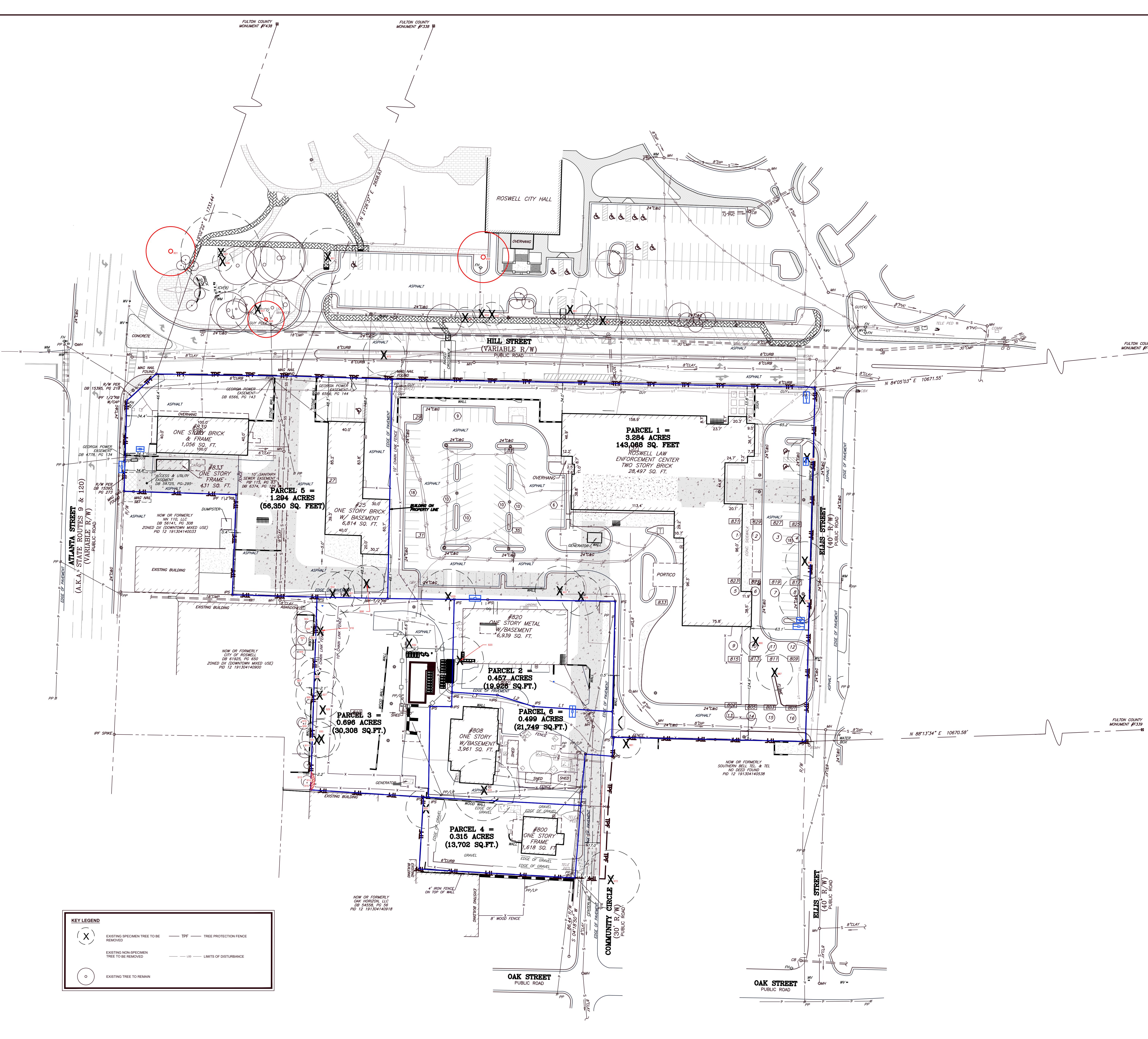
Roswell Specimen Tree Inventory - Tag 801 Species Quercus phellos Common Willow Oak DBH 27 Stems Condition Fair Specimen Yes Defects Epicormic sprouts Comments Mower damage to exposed roots 803 Lagerstroemia species Common Crapemyrtle 8 1 Good No 804 Lagerstroemia species Common Crapemyrtle 6 5 Good No 6,5,4,4,3 805 806 Lagerstroemia species Magnolia grandiflora Common Crapemyrtle Southern Magnolia 4 4 Good Good No No 4,4,4,3 807 Quercus phellos Willow Oak 27 1 Fair Yes Co-dominant at 10', Weak stem union 808 Quercus phellos Willow Oak 22 1 Fair Yes Co deminent below 5 Damage to exposed roots 809 810 Betula nigra Betula nigra River Birch River Birch 12 7 2 Good Fair No No Co-dominant below 5' Co-dominant below 5', Large dead limb 12,10 7,5″ 811 Betula nigra River Birch 10 1 Good No 815 Carya tomentosa Mockernut Hickory 13 1 Fair No Swollen base 816 817 Lagerstroemia species Lagerstroemia species Common Crapemyrtle Common Crapemyrtle 3 3 Fair Good No No Phototropic lean 2 leads removed 7,6,3" 818 Lagerstroemia species Common Crapemyrtle 6 3 Good No 6,6,4" 819 820 Quercus nigra Water Oak Water Oak 15 26 1 Good Fair No Cavity on main stom 820 Quercus nigra Quercus nigra Water Oak 10 1 Fair Yes No Cavity on main stem Asymmetrical canopy, Few dead limbs 822 Quercus nigra Water Oak 12 1 Good No 823 Quercus nigra Water Oak 15 1 Fair No Asymmetrical canopy, Mistletoe 824 825 Quercus nigra Quercus nigra Water Oak Water Oak 10 10 1 Fair Good No No Asymmetrical canopy 827 Quercus nigra Water Oak 12 1 Fair No Co-dominant at 10', Weak stem union 826 828 Quercus nigra Prunus serotina Water Oak Black Cherry 15 15 1 Fair Poor No No Co-dominant at 20', Weak stem union, Included bark Co-dominant at 5', Cavity on main stem, Large dead limb 829 Quercus falcata Southern Red Oak 30 1 Fair Yes Large dead limb, Mistletoe 830 Cornus florida Flowering Dogwood 9 1 Fair Yes Co-dominant below 5', Large dead limb 831 832 Cornus florida Magnolia grandiflora Flowering Dogwood Southern Magnolia 7 1 Good Good No No 4.2.2" 833 Quercus nigra Water Oak 34 1 Poor Yes Fungal fruiting bodies on root crown, Multiple dead limbs 4,3,3″ 834 Cornus kousa Kousa Dogwood 5 4 Good No 5,4,4,3" 802 812 Lagerstroemia species Lagerstroemia species Common Crapemyrtle Common Crapemyrtle 5 1 Good Good No No 812 Lagerstroemia species Common Crapemyrtle 5 1 Good No 814 Lagerstroemia species Common Crapemyrtle 6 1 Good No 835 836 Lagerstroemia species Lagerstroemia species Common Crapemyrtle Common Crapemyrtle 6 6 1 Good Good No No 836 Quercus nigra Water Oak 0 44 4 Fair Yes Co-dominant below 5', Epicormic sprouts 838 Cornus florida Flowering Dogwood 11 2 Poor Yes Co-dominant below 5', Severe epicormic sprouts Both leads have dead tops 839 840 Pinus taeda Pinus taeda Loblolly Pine Loblolly Pine 21 20 1 Fair Fair No No Fusiform canker Fusiform canker 841 Pinus taeda Loblolly Pine 28 1 Good No 842 Pinus taeda Loblolly Pine 25 1 Fair No Fusiform canker 843 844 Pinus taeda Magnolia grandiflora Loblolly Pine Southern Magnolia 20 11 1 Good Good No No 845 Magnolia grandiflora Southern Magnolia 9 1 Good No 846 Quercus nigra Water Oak 18 1 Fair No Co-dominant at 30', Weak stem union, Mistletoe 847 848 Quercus nigra Quercus falcata Water Oak Southern Red Oak 28 20 1 Fair Fair Yes Yes Mistletoe Mistletoe, Asymmetrical canopy 849 Platanus occidentalis American Sycamore 19 1 Good No 850 Pinus taeda Loblolly Pine 27 1 Fair No Fusiform canker 851 852 Quercus phellos Quercus phellos Willow Oak Willow Oak 31 19 1 Fair Fair Yes No Asymmetrical canopy Mistletoe Mower damage to exposed roots 853 Cornus florida Flowering Dogwood 11 1 Fair Yes Co-dominant below 5', Weak stem union 854 Cornus florida Flowering Dogwood 10 1 Fair Yes Co-dominant below 5', Few dead limbs 855 856 Cornus florida Quercus phellos Flowering Dogwood Willow Oak 13 28 1 Fair Fair Yes Yes Co-dominant below 5', Weak stem union Mistletoe, Few dead limbs 857 Lagerstroemia species Common Crapemyrtle 9 2 Good No 9,9″ 858 Lagerstroemia species Common Crapemyrtle 7 4 Good No 7,6,6,6″ 859 860 Lagerstroemia species Quercus phellos Common Crapemyrtle Willow Oak 8 15 4 Good Fair No No Mistletoe 8,7,7,6″ 861 Magnolia grandiflora Southern Magnolia 23 3 Fair Yes Co-dominant below 5', Weak stem union, Severe included bark 862 Magnolia grandiflora Southern Magnolia 13 1 Good No Condensing at holes. El Condensionat et El March store union 863 864 Magnolia grandiflora Ilex x attenuata-Fosteri Southern Magnolia Foster's Holly 18 13 1 Fair Good Yes No Co-dominant below 5', Co-dominant at 5', Weak stem union Structural root cut 865 Ilex x attenuata-Fosteri Foster's Holly 8 1 Good No 866 Ilex x attenuata-Fosteri Foster's Holly Foster's Holly 7 8 2 Good No Co-dominant at root crown 7,7" 867 868 Ilex x attenuata-Fosteri Ilex x attenuata-Fosteri Foster's Holly 8 9 2 Good Good No No Co-dominant at root crown 9,8″ 869 Acer rubrum Red Maple 14 1 Fair No Large dead limb, Girdling roots Mower damage to exposed roots; limited root zone 870 871 Acer rubrum Acer rubrum Red Maple Red Maple 11 13 1 Fair Fair No No Co-dominant at 5', Weak stem union Mower damage to exposed roots; limited root zone Mower damage to exposed roots; limited root zone 871 872 Acer rubrum Acer rubrum Red Maple 13 23 1 Fair Fair Yes Co-dominant at 5', Weak stem union Co-dominant at 10', Weak stem union Mower damage to exposed roots; limited root zone Mower damage to exposed roots; limited root zone 873 Quercus nigra Water Oak 11 2 Poor No Co-dominant at root crown, Weak stem union Growing through chain link fence 874 875 Quercus nigra Quercus nigra Water Oak Water Oak 18 5 1 Fair Fair No No Co-dominant at 10', Weak stem union, Severe included bark Co-dominant at 10', Weak stem union Tag on fence; DBH estimated 875 Quercus nigra Water Oak 10 1 Good No 877 Pinus taeda Loblolly Pine 7 1 Fair No Asymmetrical canopy 878 879 Quercus nigra Liquidambar styraciflua Water Oak Common Sweetgum 11 5 1 Good Fair No No Co-dominant at 5', Weak stem union, Included bark 880 Quercus nigra Water Oak 6 1 Fair No Co-dominant at 20', Weak stem union 881 Albizia julibrissin Mimosa Mimosa 7 1 Poor No Invasive 882 883 Quercus nigra Quercus nigra Water Oak Water Oak 7 2 Fair Fair No No Co-dominant at root crown Co-dominant at root crown, Asymmetrical canopy 7,6,5″ 7,4″ 884 Quercus nigra Water Oak 6 1 Good No 885 Paulownia tomentosa Royal Paulownia 11 1 Poor No Invasive 886 887 Paulownia tomentosa Quercus nigra Royal Paulownia Water Oak 17 5 1 Poor Fair No No Invasive Asymmetrical canopy 888 Quercus falcata Southern Red Oak 5 1 Good No Quercus nigra Water Oak 4 1 Fair Fair No Asymmetrical canony In conflict with adjacent chain link fence 890 891 Quercus nigra Pinus taeda Water Oak Loblolly Pine 15 16 1 Good No No Asymmetrical canopy In conflict with adjacent pine 892 Pinus taeda Loblolly Pine 13 1 Fair No Asymmetrical canopy In conflict with adjacent pine 893 894 Prunus serotina Black Cherry Water Oak 12 1 Fair Fair No Large dead limb Swollen base; undercut root plate 894 895 Quercus nigra Quercus nigra Water Oak Water Oak 15 15 1 Fair Fair No No Asymmetrical canopy Undercut root plate Undercut root plate 896 Pinus taeda Loblolly Pine 14 1 Poor No Fusiform canker Undercut root plate Loblolly Pine 11 1 Poor Fair No Fusiform canker Undercut root plate 897 898 Pinus taeda Water Oak 1 Fair Yes Asymmetrical canopy Asymmetrical canopy 897 898 899 Pinus taeda Quercus nigra Prunus serotina Water Oak Black Cherry 20 4 1 Fair No Asymmetrical carlopy Undercut root plate 898 899 900 Quercus nigra Prunus serotina Quercus rubra Black Cherry Northern Red Oak 4 6 1 Fair No Asymmetrical canopy 898 899 900 901 Quercus nigra Prunus serotina Quercus rubra Quercus nigra Black Cherry Northern Red Oak Water Oak 4 6 23 1 1 1 Fair Good No Yes Asymmetrical canopy 898 899 900 Quercus nigra Prunus serotina Quercus rubra Black Cherry Northern Red Oak 4 6 1 1 1 2 1 Fair No 24,24" 898 899 900 901 902 903 904 Quercus nigra Prunus serotina Quercus rubra Quercus nigra Quercus nigra Carya illinoinensis Acer rubrum Black Cherry Northern Red Oak Water Oak Water Oak Pecan Red Maple 4 6 23 24 10 12 1 1 2 1 1 Fair Good Fair Fair Fair No Yes Yes No No Asymmetrical canopy Co-dominant below 5', Weak stem union, Few dead limbs Asymmetrical canopy Asymmetrical canopy 898 899 900 901 902 903 Quercus nigraPrunus serotinaQuercus rubraQuercus nigraQuercus nigraQuercus nigraCarya illinoinensis Black Cherry Northern Red Oak Water Oak Water Oak Pecan 4 6 23 24 10 1 1 2 1 1 1 1 1 Fair Good Fair Fair No Yes Yes No Asymmetrical canopy Co-dominant below 5', Weak stem union, Few dead limbs Asymmetrical canopy Tag Species Common DBH Stems Condition Specimen Defects Comments 907 Acer rubrum Red Maple 4 1 Fair No Asymmetrical canopy 908 Quercus nigra Water Oak 4 1 Fair No Asymmetrical canopy 909 Prunus serotina Black Cherry 6 2 Poor No Co-dominant below 5', Cavity on main stem, Large dead limb 910 Acer rubrum Red Maple 5 1 Fair No Asymmetrical canopy 911 Acer rubrum Red Maple 9 1 Fair No Asymmetrical canopy 912 913 Cornus florida Acer rubrum Flowering Dogwood Red Maple 4 16 1 Fair Fair No Yes Asymmetrical canopy Co-dominant at 5', Weak stem union, Asymmetrical canopy 915 914 Prunus serotina Black Cherry 6 2 Poor No Co-dominant at 5, weak stem thion, Asymmetrical canopy Co-dominant below 5', Main lead failure 6,5"; undercut root plate 915 Quercus nigra Water Oak 4 1 Poor No Asymmetrical canopy Severe undercut root plate 916 Albizia julibrissin Mimosa Mimosa 6 1 Poor No Invasive 917 Quercus nigra Water Oak 5 1 Good No 918 Quercus nigra Water Oak 32 1 Fair Yes Co-dominant at 5', Weak stem union, Mistletoe 919 Prunus serotina Black Cherry 8 1 Fair No Asymmetrical canopy 920 Prunus serotina Black Cherry 7 2 Poor No Cavity at root crown, Severe phototropic lean 7,5"; 7" lead is dead 921 Cornus florida Flowering Dogwood 4 1 Fair No Trunk wound 922 Quercus nigra Water Oak 9 1 Fair No Asymmetrical canopy 923 Pinus taeda Loblolly Pine 26 1 Fair No Fusiform canker 924 Liquidambar styraciflua Common Sweetgum 14 1 Fair No Asymmetrical canopy 925 Quercus nigra Water Oak 12 1 Fair No Asymmetrical canopy 926 Quercus nigra Water Oak 21 2 Fair Yes Co-dominant at root crown, Weak stem union 21,21″ 927 Quercus nigra Water Oak 26 1 Fair Yes Asymmetrical canopy 928 Pinus taeda Loblolly Pine 18 1 Good No 929 Quercus nigra Water Oak 20 1 Fair Yes Asymmetrical canopy 930 Quercus nigra Water Oak 21 1 Fair Yes Asymmetrical canopy 931 Quercus nigra Water Oak 20 1 Fair Yes Asymmetrical canopy ) 32 Pinus taeda Loblolly Pine 22 2 Fair No Fusiform canker 765" 933 934 Quercus nigra Water Oak White Oak 4 1 Poor No No Cavity at root crown 7,6,5″ 934 935 Quercus alba Pinus taeda Unite Oak Lobiolly Pine 4 1 Good Fair No Asymmetrical canopy 935 936 Quercus nigra Water Oak 6 1 Fair No Asymmetrical canopy Asymmetrical canopy 930 937 Quercus nigra Water Oak 4 1 Poor No Girdling roots In conflict with adjacent oak 938 Quercus alba White Oak 15 1 Good No 939 Quercus nigra Water Oak 4 1 Fair No Asymmetrical canopy 940 Quercus nigra Water Oak 4 1 Fair No Asymmetrical canopy 941 Quercus nigra Water Oak 6 1 Fair No Poor structure 942 Prunus serotina Black Cherry 6 1 Good No 943 Pinus taeda Loblolly Pine 4 1 Poor No Fusiform canker 944 Albizia julibrissin Mimosa Mimosa 3 1 Poor No Invasive 945 Quercus nigra Water Oak 3 1 Good No 946 Quercus nigra Water Oak 13 1 Fair No Asymmetrical canopy 947 Quercus nigra Water Oak 7 1 Fair No Asymmetrical canopy, Severe epicormic sprouts 948 Quercus nigra Water Oak 15 3 Fair No Co-dominant at root crown 15,7,5″ 949 Quercus nigra Water Oak 3 1 Poor No Main lead failure, Severe epicormic sprouts 950 Quercus nigra Water Oak 4 1 Fair No Asymmetrical canopy 951 Quercus nigra Water Oak 19 1 Fair No Co-dominant at 20', Weak stem union, Severe included bark 952 Quercus nigra Water Oak 8 1 Poor No Poor location on vertical slope; DBH estimated; tag on fence 953 Quercus nigra Water Oak 10 1 Poor No Poor location on vertical slope; DBH estimated; tag on fence 954 Quercus nigra Water Oak 6 1 Poor No Poor location on vertical slope; DBH estimated; tag on fence 955 Quercus nigra Water Oak 22 1 Poor Yes Poor location on vertical slope; DBH estimated; tag on fence 956 Quercus nigra Water Oak 6 1 Poor No Poor location on vertical slope; DBH estimated; tag on fence 957 Quercus nigra Water Oak 5 Poor No Poor location on vertical slope; DBH estimated; tag on fence 958 959 Quercus nigra Water Oak Water Oak 18 5 Poor Poor No No Co-dominant at root crown Poor location on vertical slope; DBH estimated; tag on fence 5,4,4,3"; Poor location on vertical slope; DBH estimated; tag of 959 960 Quercus nigra Quercus nigra Water Oak 14 1 Poor No Poor location on vertical slope; DBH estimated; tag on fence 960 961 Quercus nigra Water Oak 4 Poor No Co-dominant at root crown 4,3"; Poor location on vertical slope; DBH estimated; tag on fe 962 Quercus nigra Water Oak 19 1 Poor No Mistletoe Poor location on vertical slope; DBH estimated; tag on fence 963 Acer rubrum Red Maple 12 1 Fair No Limbed up too far 964 Acer rubrum Red Maple 14 1 Fair No Few dead limbs 965 Lagerstroemia species Common Crapemyrtle 3 2 Good No Co-dominant at root crown 966 Lagerstroemia species Common Crapemyrtle 3 3 Good No Co-dominant at root crown 967 Lagerstroemia species Common Crapemyrtle 3 2 Good No Co-dominant at root crown 968 Lagerstroemia species Common Crapemyrtle 3 3 Good No Co-dominant at root crown 969 Lagerstroemia species Common Crapemyrtle 3 1 Good No Co-dominant at root crown 970 Magnolia x soulangiana Chinese Saucer Magnolia 11 1 Good No 971 Lagerstroemia species Common Crapemyrtle 3 2 Fair No Co-dominant at root crown, Weak stem union, Severe included bark 972 Acer saccharum Sugar Maple 32 1 Poor Yes Fungal fruiting bodies on root crown, Canopy dieback > 30% 973 Quercus nigra Water Oak 16 1 Fair No Included chain-link fence DBH estimated; tag on fence 974 Magnolia x soulangiana Chinese Saucer Magnolia 8 1 Good No 975 Paulownia tomentosa Royal Paulownia 8 1 Poor No Invasive DBH estimated; tag on fence 976 Paulownia tomentosa Royal Paulownia 10 1 Poor No Invasive DBH estimated; tag on fence 977 Pinus taeda Loblolly Pine 4 1 Poor No Fusiform canker DBH estimated; tag on fence 978 Pinus taeda Loblolly Pine 4 1 Fair No Asymmetrical canopy DBH estimated; tag on fence 979 Pinus taeda Loblolly Pine 6 Poor No Included chain-link fence DBH optimated: too an factor 980 981 Pinus taeda Cornus florida Loblolly Pine 6 1 Good Fair No Co-dominant holow El Wook storn union. Course include la la DBH estimated; tag on fence 981 982 Lagerstroemia species Flowering Dogwood Common Crapemyrtle 16 9 3 Good Yes No Co-dominant below 5', Weak stem union, Severe included bark Co-dominant at root crown 9,8,6″ 982 983 Lagerstroemia species Common Crapemyrtle 9 3 Good No Co-dominant at root crown Co-dominant at root crown 9,8,5" 9,6,5,5,4" 983 984 Lagerstroemia species Common Crapemyrtle 9 3 Good No Co-dominant at root crown 9,0,5,5,4 9,7,6″ 985 Lagerstroemia species Common Crapemyrtle 8 3 Good No Co-dominant at root crown 8,8,5″ 986 Lagerstroemia species Common Crapemyrtle 10 3 Good No Co-dominant at root crown 10,8,7" 987 Magnolia grandiflora Southern Magnolia 20 1 Fair Yes Co-dominant below 5', Weak stem union, Severe included bark 988 Magnolia grandiflora Southern Magnolia 13 2 Good No Co-dominant at root crown 13,11″ 989 Magnolia grandiflora Southern Magnolia 9 1 Good No 990 Magnolia grandiflora Southern Magnolia 17 1 Good Yes Co-dominant below 5' 991 Quercus phellos Willow Oak 26 1 Good Yes 992 Quercus phellos Willow Oak 16 1 Good No 993 Quercus phellos Willow Oak 21 1 Fair Yes Mistletoe 994 Quercus phellos Willow Oak 17 1 Good No 995 Lagerstroemia species Common Crapemyrtle 13 3 Good No Co-dominant at root crown 13,10,8" 996 Lagerstroemia species Common Crapemyrtle 8 4 Good No Co-dominant at root crown 8,7,7,5" 997 Lagerstroemia species Common Crapemyrtle 10 3 Good No Co-dominant at root crown 10,7,7" 998 Betula nigra River Birch 9 1 Good No 999 Betula nigra River Birch 8 2 Good No Co-dominant at root crown 8,7″ 1000 Betula nigra River Birch 6 1 Good No 161 Betula nigra River Birch 6 2 Good No Co-dominant at root crown 6,5″ Betula nigra River Birch 4 1 Good No Betula nigra River Birch 6 1 Good No 163 Betula nigra River Birch 2 Good No 7,7″ 463 464 Detui River Birch 9 Good No Co deminant at root array E 4" 463 464 465 Betula nigra Diver Divis 5 2 Good No No Co-dominant at root crown 5,4" 463 464 465 466 Betula nigra River Birch - 4 Card 463 464 465 466 467 Betula nigra Quercus phellos Willow Oak 16 1 Good Mictletoe 463 464 465 466 467 468 Betula nigra Quercus phellos Quercus phellos Willow Oak Willow Oak 16 21 1 1 2 Fair Yes Mistletoe 4 3″ 462 463 464 465 466 467 468 469 470 Betula nigra Quercus phellos Willow Oak 16 1 1 2 1 Mistletoe Co-dominant at root crown 4,3″
Packet Pg. 24
AN ORDINANCE TO AMEND THE UNIFIED DEVELOPMENT CODE BY MODIFYING ARTICLE 8, OVERLAYDISTRICTS WHEREAS, the City of Roswell is a Georgia municipal corporation; and WHEREAS, the Mayor and Council are the governing authority of the city; and WHEREAS, the Mayor and Council have determined that it benefits the health, safety and welfare of the citizens of Roswell to amend the Unified Development Code (UDC); and WHEREAS, the City finds that the regulations contained in this Unified Development Code (UDC) are necessary for the purposes of implementing its 2040 Comprehensive Plan adopted pursuant to the requirements of the Georgia Planning Act of 1989; and WHEREAS, this Unified Development Code (UDC) has been prepared and considered in accordance with the zoning procedures law, O.C.G.A. 66; NOW, THEREFORE, the Mayor and Council of the City of Roswell, Georgia, pursuant to their authority, do hereby amend Article 8, Overlay Districts. 1. Article 8, Overlay Districts shall be amended to create Section 8.4, HSOD – Hill Street Overlay District as follows: Sec. 8.4 Hill Street Overlay District (HSOD) 8.4.1. Purpose and Intent The Hill Street Overlay District is meant to create a vibrant, walkable, mixed-use development with exceptional public spaces and sufficient parking with the goal of concentrating residential units while strategically generating additional employment opportunities and commercial amenities. Section 13.4.3.E shall not apply to the mixed-use or multi-family building as contemplated in the HSOD "A" area. As a component of a comprehensive mixed-use project, this set of two buildings shall be allowed as labeled in Figure 2: Regulating Plan and Site Requirements.
2.1.d
2.1.d B. Overlay Areas Established The HSOD consists of two areas, as defined below: 1. HSOD "A" which includes the parcels identified in Table 1 as existing as of July 1, 2025, as shown in Figure 1 and totaling 6.419 acres. Address Parcel # Acres 839 Atlanta Street 12 -7 0.418 833 Atlanta Street 12 - 1913 - 0414 - 002 - 5 0.322 25 Hill Street 12 - 1913 - 0414 - 008 - 2 0.581 39 Hill Street 12 -0 3.27 820 Community Circle 12 - 1913 - 0414 - 010 - 8 0.45 808 Community Circle 12 - 1913 - 0414 - 011 - 6 0.4 800 Community Circle 12 - 1913 - 0414 - 079 - 3 0.315 897 Oak Street 12 - 1913 - 0414 - 038 - 9 0.663 Table 1: HSOD "A" Parcels (as of July 1, 2025) - 2. HSOD "B" which includes the remaining parcels in the Overlay boundary, as illustrated in Figure 1. The HSOD "B" parcels are bordered by the following streets: - Ellis Street from Oak Street to Hill Street - Hill Street from Ellis Street to Forrest Street - Forrest Street from Hill Street to Oak Street, and - Oak Street from Forrest Street to Ellis Street 8.4.3. Applicability HSOD "A" regulations apply to all the parcels identified in 8.4.2.A, 8.4.2.B 1 (Table 1), and as further defined by the HSOD "A" Regulating Plan and Site Requirements and Streetscape Plan (Figures 2 and 3). All projects within the HSOD "B" portion of the Overlay shall meet a minimum assemblage threshold of three (3) acres. The underlying Historic District Regulating Plan applies. When the Historic District Regulating Plan does not establish a requirement for a location, the underlying zoning district regulations apply. Any conflicts between this Overlay and other sections of the UDC shall be interpreted to allow the Overlay to govern. 3 Page
2.1.d B. Design Standards - 1. Lot frontage. - a. HSOD "A" development has no lot frontage requirement, but shall be established as approved by the Mayor and Council during major design plan review. Vehicular access to lots shall comply with Fire Marshal previous determination. - b. Townhomes are exempt from lot frontage requirements and may rely upon alleys or driveways to private streets for access, as determined by Fire Marshal. - 2. Building Height. Maximum height shall follow Table 2 dimensions. See also section 8.4.6 Table 7, Uses for Multifamily building standards for Limited Use standards. Table 2: Building Height dimensions for HSOD "A" General Per Zoning Map max (55'/4 stories)(or 3 stories) Single Story Shopfront 24'/ 1 story Mixed Use/Res; Multi-Family 55'/5 stories TO\vnhouse 55'/4 stories - 3. Building Orientation - a. The front facade and primary entrance of all buildings shall be oriented to face Hill Street, except for those within the townhome development. - b. Buildings may also be oriented to face the Public Lawn (see Figure 3)(see 8.4.5 C 3). - 4. Ground Story Minimum Height - a. Heights shall meet or exceed the following ground and upper floor minimum standards, based on building type and use, per Table 3 - Building Ground Story Height Dimensions.
Attachment: 07\Ordinance to create Sec 8.4 HSOD Hill St Overlay District\082525 (20253972 - Hill Street Mixed-Use Development - Building (Bldg) Specification & Type Ground floor min height - ft Upper Story floor min height - ft Bldg A (General) 11' 9' Bldg B (Single S. Shopfront) 12' Bldg C (Single S. Shopfront) 12' Bldg D (Single S. Shopfront) 11' Building E (General) 11' 9' Building F(SS Shopfront) 10' Building G (Mixed Use) Existing 9' Mixed Use/Res and MultiFamily Buildings 9' 9' Townhome 9' 9'
8. Transparency and Blank Wall Standards - a. Building transparency may vary, but shall meet transparency standards for ground story and upper stories as indicated in Table 4, by specific building and building type. % Ground Story Building (front/side) % Upper Story A (General) 45%/45% 40%/40% B (Single Story Shopfront) 50%/55% C (Single Story Shopfront) 60%/60% D {Single Story Shopfront ) 60%/40% E {General) 40%/30% 30%/40% F (Single Story Shopfront) 40%/30% G {Mixed Use/Non Res) 40%/20% 30%/20% Mixed Use/Res; Multi-Family 20% 20% Residential Amenity 40% 30% Townhome 20%/20% 10%/10% Parking Deck 40%/30% 50%/30% Table 4: % Transparency by Building Type and Use - b. Blank walls may vary throughout HSOD "A", depending on functionality of private street and per Building Type as indicated in Table 5. "Back of House" {BOH) walls (rear walls where commercial buildings have storage, kitchen and other non-public operations) facing interior parking areas, private streets and loading areas shall be exempt from standards (no maximum length of blank wall space). - c. BOH walls shall provide shrub and tree plantings to screen visual impact blank wall space. Plant type shall vary so as to provide varied heights. Where site constraints prohibit such plantings, the applicant shall provide an alternative fa�ade treatment, as provided by Figure 16, UDC Guidelines. 2.1.d
Table 5: Blank Wall Requirement Building Type By Use Blank Wall Max Ft Front/Side/BOH Single Story Shopfront(1) Restaurant &/or Retail 20' Single Story Shopfront (2) Restaurant &/or Retail 20'/BOH Exempt No max Single Story Shopfront (3) Restaurant & Retail 20'/ BOH Exempt No max General (1) Restaurant 12'/14'/BOH Exempt No max General (2) Residential Amenity 40'/50'/BOH Exempt No max Mixed Use Office &/or Retail 28'/7' Existing Exempt Mixed Use/MF Residential (1 bldg) Residential Mix (2nd bldg) 20'/40' Townhouse Townhomes 35' Vertical \ BOH refers to "Back of House" facade facing private street 9. Pedestrian Entrances - a. The primary pedestrian building entrance shall be located either on the front façade based on the primary street or facing a publicly accessible open space. - b. The front facing pedestrian entrance for the building on the Atlanta and Hill Street corner may be located either on the primary street front or on the corner. - 9. Utilities - a. All mechanical equipment and service areas for trash, grease traps and recycling shall be screened from public view. - 11. Building separation. The distance between the Parking Deck and adjacent structures shall be a minimum of 5' and comply with State fire code for rating and fire wall and building standards. - C. Open Space/Amenity areas - 1. A minimum of 10% of the development shall be set aside for landscaped open space, as defined in Section 2.2.6 - 2. A minimum of 13% of the development shall be set aside for amenity area, as defined in UDC Section 2.2.7 - 3. A publicly accessible lawn available for public use, shall be incorporated into the master design. The public lawn shall serve as a recreational gathering place to which the general public has access and a right to frequent for public use. The area may count towards required amenity area square footage calculations. 2.1.d 8 Page
Ordinance No. 07
E. Canopies. Within the development, all canopies shall have minimum depth of four (4) feet and a clear height of nine (9) feet. All awnings a minimum depth of three (3) feet. All balconies shall have clear height of nine (9) feet. F. Parking 1. The Planning and Zoning Director shall have the authority to approve a parking plan that varies from the UDC parking standards as long as it complies with an approved Development Agreement and Parking Agreement with the City. 2. Townhome development within HSOD "A" shall provide each unit a minimum of two parking to each unit (garages may serve to meet this minimum). No additional visitor parking required. G. Parking Deck The parking deck to be constructed within the development shall be approved by the Mayor and Council. The parking deck does not need to meet the use standards set in Section 9.5.7 or section 10.1.15 of the Unified Development Code. H. Signage Signage shall be regulated by a Master Sign Plan, reviewed and approved by Mayor and Council. Where any conflicts exist between the Master Sign Plan and the UDC, the Master Sign Plan shall govern. Where the Master Sign Plan is silent, the UDC regulations shall govern. The Master Sign Plan should be consistent with the current code where possible. The design submittal shall identify differences (dimensions, style, material, lighting) between the two documents, if any. 8.4.6 Use Standards for HSOD "A" A. Permitted Uses The Tables 6 and 7 below list the permitted and limited uses within the HSOD "A" component of the Overlay. Uses not listed are prohibited and follow UDC authority for interpretation of like uses. 11 Page
Permitted Exceptions by Use (Prohibited) 1. Gym, health spa, yoga studio 2.Parking on site 3. Commercial Parking 4. Remote Parking 5. Art Gallery 6. Micro-brewery 7. Cigar lounge 8. Massage Therapy 9. All retail sales 9. RETAIL: Except: vape shops, CBD, tobacco shop; pawn shop; Vehicle sales; Dispensary; firework sales; convenience stores 10. All Office 10. OFFICE: Except for: bail bonds, call center; title loans/check cashing 11. Beauty, Hair, Nail Salon 12. All restaurant 12. RESTAURANTS: Except Drive-throughs 2.1.d
Use Limited Multi-Family Residential The Mixed Use/MF and Multi-Family buildings located in the interior of the site shall be a maximum of five (5)stories and no more than fifty-five (55)feet in height. Where the lot slopes downward, an additional story may be built on the lower rear portion of the lot for storage and stabilization of the building. HSOD A allows 1 Mixed-Use/MF Residential Building and 1 MF residential Building, per the Regulating Plan. The latter use shall only be permitted with an accompanying, executed Developer Agreement. Max Dwelling Units #: 143 Max Dwelling Units on ground floor #: 12 Location ground floor dwelling units: fronting Community Circle Townhome Residential Single Family residential use only Lot Size: Shall be determined by Mayor and Council at design submittal approval. Min Total units #:16 Min lot width: 22 ft; zero lot line between townhomes No more than 20% of units in a townhouse development may be leased at any given time. The Home Owner Covenants and By-laws shall include a clause incorporating this section. Hotel/Boutique Hotel Council shall have sole authority over approval of hotel applicant concept submittals and design 2.1.d
2.1.d 8.4.7 Building Types for HSOD "A" - A. The following building types shall be permitted: - 1. General - 2. General Residential Amenity - 3. Mixed use/nonresidential - 4. Mixed use/multi-family and Multi-Family (max 1 structure each) - 5. Townhomes - 6. Single story shopfront - B. Vertically integrated mix of uses and total commercial area - 1. A minimum of two uses shall be incorporated into each mixed-use building. - 2. A minimum of 72,000 square feet of the development shall be utilized as commercial uses (inclusive of outdoor leased or leasable premises, such as rooftops and patios, but excluding outdoor common areas). Commercial uses refer to the permitted, non-residential uses in Section 8.4.6. 8.4.8 Development Schedule for HSOD "A" - A. Except for the townhome development, parcels located within the HSOD "A" shall be completed in a single, integrated phase. - B. The commercial buildings shall be completed simultaneously with or prior to the occupancy of the mixed-use multi-family or multi-family buildings within the project. - C. No certificates of occupancy shall be issued for multi-family residential components of the project prior to the completion of the commercial components. 8.4.9 Design Standards/Regulations for the HSOD "B" Site parcels - A. The underlying zoning and Historic District regulation apply to all projects within the HSOD "B", and any HSOD "B" Townhome development shall be subject to TH standards within the DX Zoning District. - B. Acreage requirements. A minimum of three (3) contiguous acres required for assemblage for a Townhome development. - C. Building Height - 1. All structures within HSOD "B" shall have a 3 and 1/story maximum height. - D. Building size - 1. Must meet all requirements of the building types in Article 5 of the Unified Development Code, except for the following: - a. Townhomes must have a unit width minimum of twenty-four (24) feet.
E. Utility Poles - Any existing utility poles shall be relocated to underground utility conduits. Any new utilities must be located underground - F. Stormwater. All stormwater must meet the requirements of the City of Roswell. - G. Open Space/Amenity areas - 1. Landscaped opens space and amenity areas shall be operated and maintained by the HOA or development group. - 2. Tree Density as per the Unified Development Code which for the Historic District Character Area is ten (10) units per acre. - H. Sidewalk and Road Improvements - The sidewalk widths along Hill Street, Ellis Street, Oak Street and Forrest Street are all required to be a ten (10) feet multi-use sidewalk/trail as approved by the Roswell Department of Transportation (RDOT). - 2. Based on any traffic study and any new development plan, the Roswell Department of Transportation shall determine if there is a need for an elevated crosswalk with any new development for this area. 8.4.10 Use Standards for HSOD "B" Sites - A. The parcels located in the HSOD "B" Sites per Figure 1 Hill Street Overlay District map follow the zoning use charts for their underlying zoning district for permitted and prohibited uses. - B. On the parcels that are zoned IX (Industrial Flex) located in the HSOD "B" Sites per the map, townhomes will be an additional use that will be permitted as long as the townhome development contains a minimum of 3 acres and meets all of the requirements indicated in the Design Standards for the HSOD "B" Sites. A Townhome development shall contain no other uses except residential. - C. Nonconforming uses shall be governed by Section 13.13 of the Unified Development Code. - D. IX parcels within the HSOD "B" area seeking and receiving approval of a townhouse development according to these provisions, shall adhere henceforth to DX district standards alone; acceptance of a TH development approval limits the site to TH development only. Further, a TH development shall be constructed as a stand-alone townhouse residential use, without any other primary uses permitted with the residential site. - E. Single Family Detached Residential use may be considered by Mayor and Council by a text amendment modification to the HSOD.
F. No more than 20% of units in a townhouse development may be leased at any given time. The Home Owner Covenants and Bylaws shall include a clause incorporating this section. 2. Severability. Should any court of competent jurisdiction declare any section or part of this Ordinance invalid or unconstitutional, such declaration shall not affect the validity of the Ordinance as a whole or any part thereof, which is not specifically declared to be invalid or unconstitutional. 3. Repeal of Conflicting Provisions. All ordinances, parts of ordinances, or regulations in conflict herewith are repealed. Renumbering. It is the intention of the Mayor and Council, and it is hereby ordained that the provisions of this Ordinance shall become and be made a part of the Code of Ordinances, City of Roswell, Georgia and the sections of this Ordinance may be renumbered to accomplish such intention. 4. This Ordinance shall take effect and be in force from and after the day of its adoption, the public welfare demanding it. The above Ordinance was read and approved by the Mayor and Council of the City of Roswell, Georgia, on the 25th day of August 2025. Approved: Kurt M. Wilson, Mayor Attest: Nancy Saviano Long, City Clerk SEAL
Ordinance No. 07 2.1.d Regular Meeting Monday, August 25, 2025 Approval of a Text and Map Amendment to the Unified Development Code (UDC) for the Hill Street Overlay (HSOD). (Second Reading) Ordinance No. 07 RESULT: MOVER: APPROVED ON SECOND READING [UNANIMOUS] Allen Sells, Councilmember SECONDER: William Morthland, Councilmember IN FAVOR: Beeson, Hall, Hills, Johnson, Morthland, Sells City Attorney's Report 5. #10005 Recommendation for Closure to Discuss Personnel, Litigation and Real Estate. RESULT: NO CLOSURE Adjournment The meeting was adjourned at 8:11 PM
City of Roswell Planning Commission Special Called AGENDA ITEM REPORT ID # - 10072 MEETING DATE: September 23, 2025 DEPARTMENT: Planning Commission ITEM TYPE: Minutes July 21, 2025 PC Special Called Meeting Minutes Item Summary: July 21, 2025 Planning Commission Special Called Meeting Minutes
Planning Commission Special Called Meeting http://www.roswellgov.com/ ~Minutes~ Chair Kitty Singleton Vice Chair Eric Schumacher Commissioner Jason Frazier Commissioner Pooja Gardner Commissioner Charles Krieger Commissioner Jim Walsh Commissioner Carol Williams Monday, July 21, 2025 City Hall - 1:00 PM Room 220 \ Possible Quorum of Mayor and City Council \* Welcome I. Call to Order The meeting was called to order at 1:00 PM by Chair Kitty Singleton Chair Kitty Singleton: Present, Vice Chair Eric Schumacher: Present, Commissioner Jason Frazier: Present, Commissioner Pooja Gardner: Present, Commissioner Charles Krieger: Present, Commissioner Jim Walsh: Present, Commissioner Carol Williams: Present, Deputy City Administrator & Senior Vice President Jeffrey Leatherman: Present, Assistant City Attorney Joseph Cusack: Present, Director of Community Development Michelle Alexander: Present, Planning and Zoning Director Jeannie Peyton: Present, Planner III Angela Rambeau: Present, Director of Economic Development Darryl Connelly: Present, SEER Economic Development Contractor Wesley Smith: Present. II. Text Amendments 1. Review of a Text and Map Amendment to the Unified Development Code for the Hill Street Overlay. Eric Schumacher nominated Kitty Singleton to act on behalf of the Planning Commission to work with staff to merge those changes for the Hill Street Overlay and make a document available for Mayor and Council. The Commission voted unanimously in favor of this motion. RESULT: DISCUSSED III. Adjournment** There being no further comments or discussion the meeting was adjourned at 5:18 PM

Images Found in Document

51 image(s) extracted

_page_1_Picture_0.jpeg

_page_1_Picture_0.jpeg

.JPEG

_page_2_Picture_0.jpeg

_page_2_Picture_0.jpeg

.JPEG

_page_3_Picture_0.jpeg

_page_3_Picture_0.jpeg

.JPEG

_page_4_Picture_1.jpeg

_page_4_Picture_1.jpeg

.JPEG

_page_5_Picture_1.jpeg

_page_5_Picture_1.jpeg

.JPEG

_page_6_Picture_0.jpeg

_page_6_Picture_0.jpeg

.JPEG

_page_6_Picture_2.jpeg

_page_6_Picture_2.jpeg

.JPEG

_page_7_Picture_0.jpeg

_page_7_Picture_0.jpeg

.JPEG

_page_7_Figure_1.jpeg

_page_7_Figure_1.jpeg

.JPEG

_page_8_Picture_22.jpeg

_page_8_Picture_22.jpeg

.JPEG

_page_9_Picture_1.jpeg

_page_9_Picture_1.jpeg

.JPEG

_page_10_Picture_1.jpeg

_page_10_Picture_1.jpeg

.JPEG

_page_11_Picture_1.jpeg

_page_11_Picture_1.jpeg

.JPEG

_page_12_Picture_0.jpeg

_page_12_Picture_0.jpeg

.JPEG

_page_13_Figure_40.jpeg

_page_13_Figure_40.jpeg

.JPEG

_page_13_Picture_52.jpeg

_page_13_Picture_52.jpeg

.JPEG

_page_13_Picture_56.jpeg

_page_13_Picture_56.jpeg

.JPEG

_page_13_Picture_57.jpeg

_page_13_Picture_57.jpeg

.JPEG

_page_13_Figure_60.jpeg

_page_13_Figure_60.jpeg

.JPEG

_page_14_Figure_2.jpeg

_page_14_Figure_2.jpeg

.JPEG

_page_14_Figure_3.jpeg

_page_14_Figure_3.jpeg

.JPEG

_page_14_Figure_12.jpeg

_page_14_Figure_12.jpeg

.JPEG

_page_14_Figure_15.jpeg

_page_14_Figure_15.jpeg

.JPEG

_page_15_Figure_46.jpeg

_page_15_Figure_46.jpeg

.JPEG

_page_16_Figure_0.jpeg

_page_16_Figure_0.jpeg

.JPEG

_page_16_Figure_1.jpeg

_page_16_Figure_1.jpeg

.JPEG

_page_16_Figure_3.jpeg

_page_16_Figure_3.jpeg

.JPEG

_page_17_Figure_0.jpeg

_page_17_Figure_0.jpeg

.JPEG

_page_17_Figure_6.jpeg

_page_17_Figure_6.jpeg

.JPEG

_page_17_Figure_7.jpeg

_page_17_Figure_7.jpeg

.JPEG

_page_17_Figure_10.jpeg

_page_17_Figure_10.jpeg

.JPEG

_page_18_Figure_0.jpeg

_page_18_Figure_0.jpeg

.JPEG

_page_18_Figure_1.jpeg

_page_18_Figure_1.jpeg

.JPEG

_page_18_Figure_4.jpeg

_page_18_Figure_4.jpeg

.JPEG

_page_19_Figure_4.jpeg

_page_19_Figure_4.jpeg

.JPEG

_page_20_Figure_0.jpeg

_page_20_Figure_0.jpeg

.JPEG

_page_20_Figure_2.jpeg

_page_20_Figure_2.jpeg

.JPEG

_page_21_Figure_0.jpeg

_page_21_Figure_0.jpeg

.JPEG

_page_21_Figure_2.jpeg

_page_21_Figure_2.jpeg

.JPEG

_page_22_Figure_0.jpeg

_page_22_Figure_0.jpeg

.JPEG

_page_22_Figure_4.jpeg

_page_22_Figure_4.jpeg

.JPEG

_page_23_Figure_0.jpeg

_page_23_Figure_0.jpeg

.JPEG

_page_23_Figure_4.jpeg

_page_23_Figure_4.jpeg

.JPEG

_page_24_Figure_0.jpeg

_page_24_Figure_0.jpeg

.JPEG

_page_24_Figure_2.jpeg

_page_24_Figure_2.jpeg

.JPEG

_page_26_Figure_8.jpeg

_page_26_Figure_8.jpeg

.JPEG

_page_28_Figure_12.jpeg

_page_28_Figure_12.jpeg

.JPEG

_page_34_Figure_0.jpeg

_page_34_Figure_0.jpeg

.JPEG

_page_40_Picture_17.jpeg

_page_40_Picture_17.jpeg

.JPEG

_page_42_Picture_0.jpeg

_page_42_Picture_0.jpeg

.JPEG

_page_43_Picture_1.jpeg

_page_43_Picture_1.jpeg

.JPEG

Loading...