Back to Documents

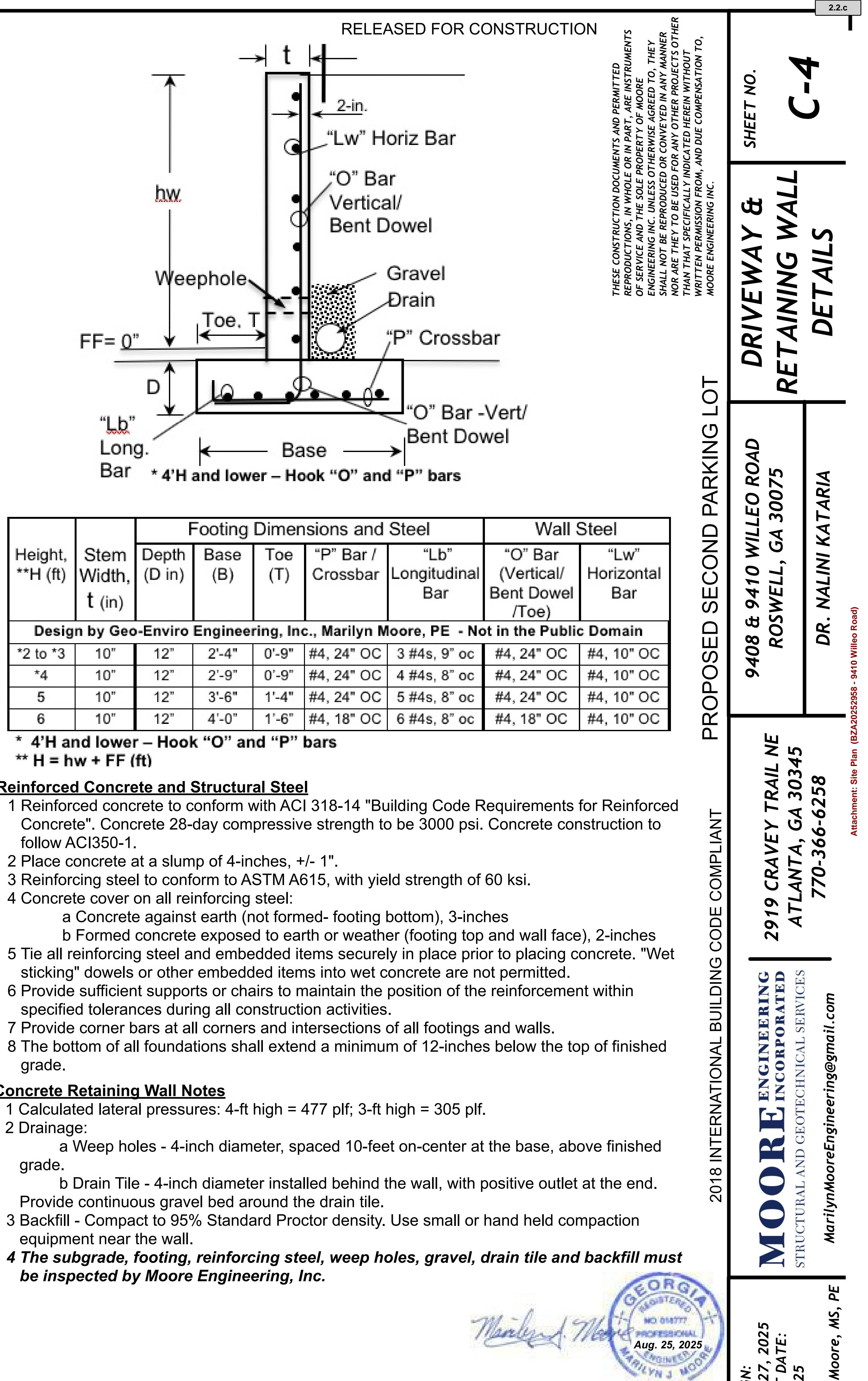
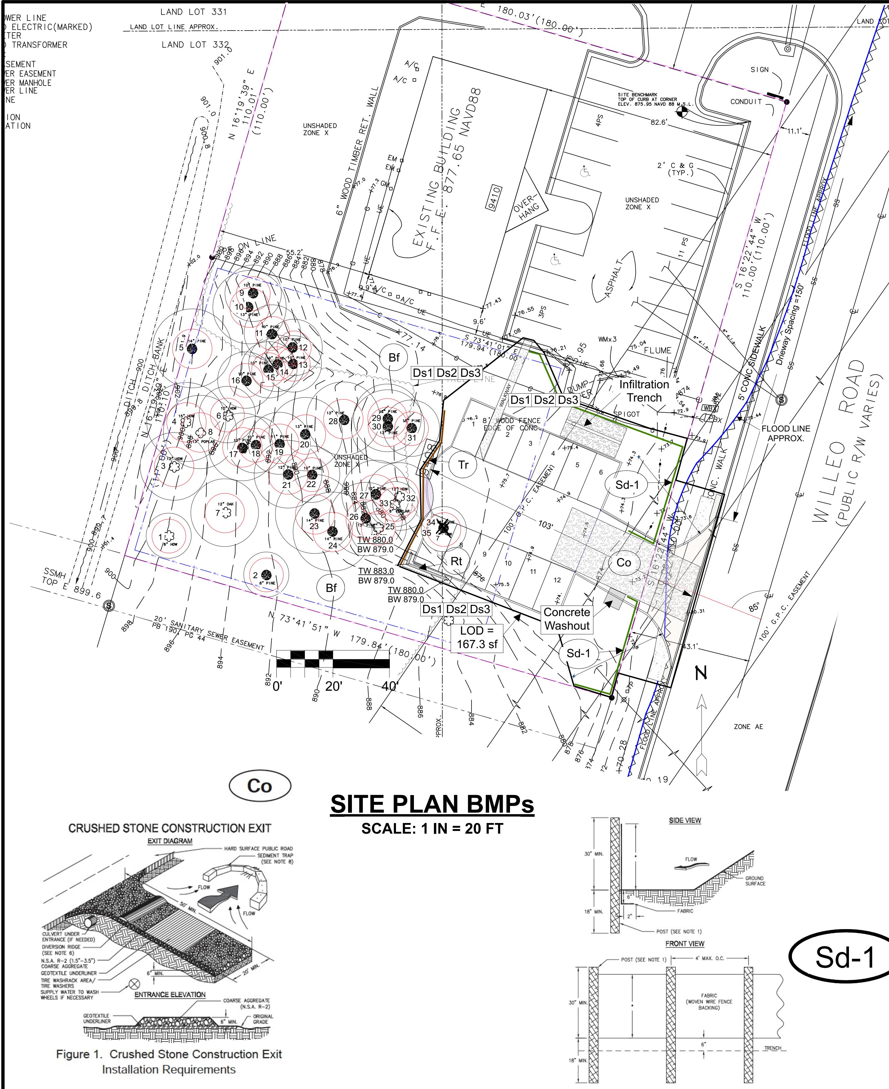
Board of Zoning Appeals Agenda

PDF Board of Zoning Appeals Sep 09, 2025 at 07:00 PM Processed: Sep 02, 2025 at 10:25 PM

PDF Content

Pages: 56

Board of Zoning Appeals Regular Meeting http://www.roswellgov.com/ ~Agenda~ Chair Jahanzeb Jabbar Vice Chair Mark Schumacher Board Member John Hannah Board Member G. Wilson "Rocky" Horde Board Member Rob Huey Board Member Ian Kowalski Board Member Dan Seger Tuesday, September 9, 2025 7:00 PM City Hall - Council Chambers \ Possible Quorum of Mayor and City Council \* Welcome - I. Call to Order - II. Agenda Items - 1. BZA20252054 – 12250 Brookfield Club Drive – variance to reduce the rear & side setbacks for a sport court (previously deferred) - 2. BZA20252958 – 9410 Willeo Road – variance requests to parking regulations - III. Minutes - 3. August 12, 2025 BZA Minutes - IV. Adjournment**
City of Roswell Board of Zoning Appeals AGENDA ITEM REPORT ID # - 9984 MEETING DATE: September 9, 2025 DEPARTMENT: Board of Zoning Appeals ITEM TYPE: Public Hearing BZA20252054 - 12250 Brookfield Club Drive Item Summary: Variance to reduce the side and rear setbacks for a Sport Court. Committee or Staff Recommendation: Staff recommends approval of both variance requests. Financial Impact: N/A Presented by: Richard Sykes 2.1
Petition Number BZA20252054 Hearing & Meeting Date Board of Zoning Appeals - 08/12/2025; Deferred to 09/09/2025 Applicant Josh Katterheinrich 12250 Brookfield Club Drive, Roswell, Georgia 30075 Property Information 12250 Brookfield Club Drive Zoning – RS-18 Proposed variance Variance to reduce the accessory structure side setback from 10 feet to 3.8 feet. Variance to reduce the accessory structure rear setback from 10 feet to 3.4 feet. Staff Recommendation: Staff recommends approval of both variance requests. Item was presented to the BZA on 8/12/2025. Staff gave their presentation and recommended approval of both variance requests. The applicant then gave their presentation. Multiple members of the public, who all live in the same neighborhood of the applicant, spoke in favor and opposition of the variance requests. The BZA voted to defer the item to the 09/09/2025 meeting. Per BZA deferral of this application on the 8/12/2025 meeting, staff is recommending approval of both variance requests with the following conditions: - 1. That the applicant plants three Chindo Viburnum and six Cleyera bushes between the Sport Court and rear property line as depicted on the landscape plan dated 8/23/2025. - 2. That the applicant limits the use of the Sport Court between 7:00 a.m. to 10:00 p.m. - 3. That the applicant ensures that any outside lighting used to illuminate the Sport Court shall be located, aimed or shielded so as to minimize glare and stray light trespassing across the adjacent property boundaries.
Background This property is zoned RS-18 Single-Family Residential and is 40,114 square feet (0.92 acres) in size. It has one road frontage off Brookfield Club Drive and is part of the Brookfield West subdivision. The lot is generally triangular shaped with a foot front setback, foot side setbacks and a foot rear setback for the primary structure. The accessory structure setbacks for the lot are 40 feet for the front and ten feet for the side and rear. The primary structure is a 4,189 square foot single-family house that is located in a cul-de-sac. The front yard consists of a lawn and small to medium sized vegetation with a driveway that abuts the western side property line and leads to a side-loaded garage. The neighbor to the rear of the property has a fence along a portion of the rear property line. The backyard contains a patio, retaining wall, sporadic trees and small vegetation. The applicant has built a 1,350 square foot Sport Court 3.4 feet from the rear property line and 3.8 feet from the west side property line. The Sport Court is approximately 100 feet from the side neighboring house to the west of the property, approximately 70 feet from the rear neighboring house northeast of the property, and approximately 85 feet from the rear neighboring house northwest of the property. The applicant did not apply for a Variance nor a Land Disturbance Permit, prior to building the Sport Court and is now asking for two variances for the existing accessory structure. The topography of the backyard severely limits the buildable area and thus the Sport Court was built on the flattest area on top of a small hill in the northwest corner of the property. The applicant received a tree permit to clear the area for the Sport Court and received a building permit for a retaining wall that supports the Sport Court. It was the retaining wall building permit that brought the Sport Court to the attention of city staff. The applicant applied for an administrative variance originally, but after receiving two opposition letters from the adjacent neighbors, the applicant was then required to apply for a major. Attachment: Updated Staff Report 12250 Brookfield Club Dr (BZA20252054 - 12250 Brookfield Club Drive)
Request - 1. The applicant is seeking relief from the UDC 3.2.3.1.J to reduce the accessory structure side setback from 10 feet to 3.8 feet. This is an encroachment of 6.2 feet. - 2. The applicant is seeking relief from the UDC 3.2.3.1.K to reduce the accessory structure rear setback from ten 10 to 3.4 feet. This is an encroachment of 6.6 feet. References - 1. UDC 3.2.3; Detached House, Number 1, Letter J: Side interior (min): 10' - 2. UDC 3.2.3; Detached House, Number 1, Letter K: Rear (min): 10' Attachment: Updated Staff Report 12250 Brookfield Club Dr (BZA20252054 - 12250 Brookfield Club Drive)
Aerial Image:
Zoning Map:
Topography Map 6
Proposed Site Plan
Proposed Site Plan Enlarged
Proposed Landscape Plan 2.1.a
Sign Photo: 2.1.a
View from Brookfield Club Drive: View of Sport Court from Applicant's Driveway 11
13.11.7 BZA Hardship Criteria: Variance to reduce the side and rear setbacks. A. A literal interpretation of the provisions of this UDC would effectively deprive the applicant of rights commonly enjoyed by other properties of the zoning district in which the property is located. A literal interpretation of the provisions of this UDC would effectively deprive the applicant of rights commonly enjoyed by other properties of the RS-18 zoning district. The topography of the lot limits the buildable area in the backyard. Whereas other properties with a flatter topography can build in their backyard without seeking a variance, the varied topography on this lot limits the buildable area to where the Sport Court currently resides. B. Granting the requested variance will not confer upon the property of the applicant any special privileges that are denied to other properties of the zoning district in which the property is located. Granting the requested variance will not give the applicant any special privileges, as the property is a lot of record, and the applicant has the right to maximize the use and enjoyment of the property. C. The requested variance will be in harmony with the purpose and intent of this UDC and will not be injurious to the neighborhood or to the general welfare. The requested variance will be in harmony with the purpose and intent of the UDC and Comprehensive Plan and will not be injurious to the neighborhood or to the general welfare. Many other lots in the Brookfield West subdivision have, including the adjacent property to the rear of the lot, swimming pools installed in their backyards. Like a Sport Court, swimming pools are used as recreation. Therefore, the requested variance will match the existing character and development patterns of the neighborhood as mandated in Neighborhood Residential Character Area of the Comprehensive Plan. D. The special circumstances are not the result of the actions of the applicant. The special circumstances are not the result of the actions of the applicant as the varied topography of the lot is existing. However, this case has been complicated by the applicant as the Sport Court was built without making an application for and receiving a variance and Land Disturbance Permit.
E. The variance requested is the minimum variance that will make possible the proposed use of the land, building or structure. The requested variance is the minimum variance possible that allows the Sport Court to be built on the most level area of the backyard. F. The variance does not permit a use of land, buildings or structures, which is not permitted by right in the zoning district. Per the Brookfield West plat, this is a lot of record and an accessory structure is allowed. G. The variance does not reduce the lot size below the minimum lot size allowed in the zoning district. The variance does not reduce the lot size below the minimum lot size allowed in the zoning district. H. The variance does not increase the maximum allocation of sign area or the maximum area of an allowed sign type. The variance does not pertain to signs.
FOR SINGLE-FAMILY RESIDENTIAL USE ONLY WITH LESS THAN 5,000 SQUARE FEET OF NEW OR REPLACED IMPERVIOUS AREA French Drain A French drain consists of a shallow trench filled with stone and fitted with a perforated pipe. Stormwater from impervious areas including roofs, driveways, and pool decks is piped to the French drain and infiltrates into the surrounding soil. French drains must exit at a point that is lower than the inflow point and flow away from structures. French drains are usually covered with topsoil and sod so they blend in with landscaping while providing stormwater benefits. Locate - Install the French drain at least 10 feet away from building foundations. - Avoid septic fields, utility easements, and public right-of-way - Install in a landscaped area. - Use a perforated pipe to receive roof drains pipes. - The perforated pipe must have a positive slope away from the structure and must exit at a point that is lower than the inflow point. The exit location must be at least 10 feet from the property line and cannot channel flow onto a neighboring property. Design - Two options are available for this design; Option 1 and Option 2. Option 1 does not receive surface flow. Option 2 can receive surface flow. - The minimum depth of a French drain is 18 inches. The maximum depth is 30 inches. - To calculate the width and length, see the table below. - See the next page for details. Area of Impervious Surface in Square Feet Which Can be Treated Per 10 Linear Feet of French Drain Trench Depth (inches) Trench Width (inches) 18 24 30 18 100 150 250 24 150 200 300 30 250 350 Maintain 10 lin ft of MFD treats 200 sq ft of impervious 71 lin ft treats 1,420 sq ft of imperivious - Inspect gutters and downspouts for accumulated leaves. - Inspect the trench following rain events. Removed accumulated leaves and debris. - Monitor for and repair areas of erosion. FOR SINGLE-FAMILY RESIDENTIAL USE ONLY WITH LESS THAN 5,000 SQUARE FEET OF NEW OR REPLACED IMPERVIOUS AREA www.Georgia811.com Ridley H Hailey Level II Certified Design Professional CERTIFICATION NUMBER \\\\\\\\\\\\\\\\\\
20252054
HOW TO REQUEST A VARIANCE BEFORE THE BOARD OF ZONING APPEALS If you cannot meet all the standards and regulations of the Roswell Unified Development Code, you may present your request for a Variance before the Board of Zoning Appeals. A Variance is a relaxation of the strict terms of the Unified Development Code (such as height, setbacks, parking or other regulations) for a specific property, to permit construction that would otherwise be prohibited because of the particular physical surroundings, shape or topographical conditions. Variances are covered in the Section 13.11, "Variance," of the Roswell Unified Development Code. You must present your request to the Board in the form of a hardship that you will experience if the strict application of the zoning regulation is enforced. In granting a Variance, the Board of Zoning Appeals may impose requirements and conditions to protect adjacent properties and the public interest. Any application for a Variance must be supported by written verification of that: There are extraordinary and exceptional conditions or practical difficulties pertaining to the particular piece of property in question because of its size, shape or topography that are not applicable to other lands or structures in the same district. $\epsilon$ S In making this determination, the Board of Zoning Appeals considers the following criteria: - A literal interpretation of the provisions of this UDC would effectively deprive the applicant of rights commonly enjoyed by other properties of the district in which the property is located. $\sqrt{e\varsigma}$ - Granting the Variance requested will not confer upon the property of the applicant any special privileges that are $\mathbf{r}$ denied to other properties of the zoning district in which the property is located. $\mathcal{N}_
$ - The requested Variance will be in harmony with the purpose and intent of this UDC and will not be injurious to the neighborhood or to the general welfare. $\sqrt [PAGE 7 - UNMATCHED] $ - The special circumstances are not the result of the actions of the applicant. $\sqrt
$ U - The Variance requested is the minimum variance that will make possible the proposed use of the land, building, or $\mathbb{R}$ structure. 45 - The Variance does not permit a use of land, buildings or structures, which are not permitted by right in the zoning $\blacksquare$ district. - The Variance does not reduce the lot size below the minimum lot size allowed in the zoning district. $\ell/\ell$ $\overline{a}$ - The variance does not increase the maximum allocation of sign area or the maximum area of an allowed sign type, $\blacksquare$ REQUESTING AN ADMINISTRATIVE VARIANCE An Administrative Variance is similar to a Variance in that it also grants relief from the strict requirements of the Unified Development Code. An Administrative Variance does not require a public hearing. The Zoning Director may "administratively" vary or waive any of the certain requirements as outlined in Section 13.9 of the Unified Development Code. Details are covered on the Variance Checklist. $2.1.d$
READ CAREFULLY BEFORE SIGNING I understand that failure to supply all required information (per the relevant Applicant Checklist and requirements of the $\blacksquare$ Unified Development Code) will result in REJECTION OF THE APPLICATION. I understand that the application may not be approved if applicant plans to attend the Design Review Board meeting $\blacksquare$ without required items or if the applicant presents plans that differ from submittal materials. I understand that I will become familiar with applicable zoning code and Design Guidelines. $\blacksquare$ Applicant or Representative Signature Date I respectfully petition that this property be considered as described in this application. Wherefore, applicant prays that the procedures incident to the presentation of this petition be taken, and the property be considered accordingly. Additionally, applicant further acknowledges and fully understand all above statement made by the City of Roswell. I hereby certify that all information provided herein is true and correct Property Owner Signature Date Address: rive Drook field State: City: Koswer Zip: 30075 NOTARY: Personally appeared before me the above applicant or representative named A GITOCH who on oath says that he/she is the applicant or representative for the foregoing, and that all the above statements are true to the best of his/her knowledge JORGE PERALTA NOTARY PUBLIC Gwinnett County State of Georgia My Comm. Expires Feb. 13, 2028 Notary Signature Date 2026 Date commission expires:
VARIANCE CHECKLIST - 1. Completed and signed application form. - 2. Payment of applicable fee. - 3. Letter of Intent: - $\bullet$ Describing the requested variance( $s$ ); and - Describing how the proposed action meets the criteria for granting of a variance as established in Article 13.11.17 of the Roswell Unified Development Code. - 4. One to-scale copy of a survey sealed by a surveyor or a site plan, which must contain the required items related to the variance request. - Metes, bounds, and dimensions; - Bearings and distances; - Current zoning of subject property; - Property lines: - Existing buildings and structures including retaining walls; - Existing parking; and - Topographical information (significant man-made and natural features, streams, stream buffers, historic and archaeological sites) - Total site area [SqFt and acreage]: - Existing building footprint and proposed building footprint; - Proposed building and structures, including retaining walls: - Proposed setbacks; - Proposed parking; and - Other information required by the Planning and Zoning Director - 5. If a sign variance is requested, please provide the following: - Color rendering of the proposed sign, drawing to scale (architect, sign contractor, or engineer) with sign dimensions (height and width) - Digital copy of all required documentation. 6. ADMINISTRATIVE VARIANCE CHECKLIST - 1. Provide the proposed site plan with proposed request containing: - Printed name(s) of abutting property owner(s); - Address of the abutting property owner(s) $\mathbf{S}$ - 2. Digital copy of all required documentation. Once the application is submitted, per Unified Development Code Section 13.9.6, a letter will be sent to each abutting property owner regarding the requested variance. Each owner will have ten (10) calendar days from the date the notice is received to object to the request by sending the objection in writing to the Planning and Zoning Director.
Fee Schedule – Board of Zoning Appeals Variance Commercial/Sign $$ + starred items below \$350 Variance Residential + starred items below \$250 Administrative \$100 Advertising \$300 Public notice signs \$120/sign 2025 BOARD OF ZONING APPEALS MEETING DATES Tuesday, January 14, 2025 Tuesday, February 11, 2025 Tuesday, March 11, 2025 Wednesday, April 16, 2025 Moved due to Spring Break Tuesday, May 13, 2025 Tuesday, June 10, 2025 Tuesday July 8, 2025 Tuesday, August 12, 2025 Tuesday, September 9, 2025 Thursday, October 16, 2025 Rescheduled due to Columbus Day Thursday, November 13, 2025 Rescheduled due to Veteran's Day No December 2025 Meeting Packet Pg. 22
City of Roswell Board of Zoning Appeals AGENDA ITEM REPORT ID # - 10054 MEETING DATE: September 9, 2025 DEPARTMENT: Board of Zoning Appeals ITEM TYPE: Public Hearing BZA20252958 - 9410 Willeo Road Item Summary: 1. Variance to allow parking between the building and the street 2. Variance to increase the maximum parking requirement. Committee or Staff Recommendation: Planning and Zoning recommends approval of both variance requests. Financial Impact: N/A Presented by: Richard Sykes
Petition Number BZA20252958 Hearing & Meeting Date Board of Zoning Appeals - 09/09/2025 Applicant Marilyn Moore Moore Engineering, Inc. 2919 Cravey Trail NE Atlanta, Georgia 30345 Property Information 9408/9410 Willeo Road Zoning – Office Park (OP) Proposed variance Variance to allow on-site parking between the building and the street. Variance to increase the maximum parking requirement. Staff Recommendation: Staff recommends approval of both variance requests. Background This property is zoned Office Park (OP) and is about 39,600 square feet (.91 Acres). It has a frontage off Willeo Road and a frontage off Willeo Exchange which is a private street. The property has an existing 3,400 square foot commercial building and an approximate 6,751.4 square foot existing parking lot located in the northeastern half of the property. The southwestern half of the property consists of a grass lawn near Willeo Road and dense trees and smaller vegetation towards the rear of the property. The single entrance/exit to the property is off Willeo Exchange close to the intersection of Willeo Exchange and Willeo Road. The existing building faces Willeo Road and the existing parking lot has 20 spaces with two handicapped dedicated spaces. The area behind the existing building has a line of tall pine trees which act as a vegetative buffer. Before March 2025, the existing building had two suites, a dentist office and a chiropractor. In 2019, the property was divided into two lots, 9410 and 9408 Willeo Road. In 2024, the two lots were combined back into a single lot with the intention of expanding the parking lot. The two street addresses 9410 and 9408 remain tied to the combined lot. The property owner has a dental
office in the existing building which has recently expanded from one suite to both suites, combing the two in March 2025. The applicant intends to build a 4,838.9 square foot parking lot extension which includes a new entrance and driveway off Willeo Road and 12 parking spaces. This would bring the total number of parking spaces on the property to 32. The proposed parking lot extension will include two landscape islands and a landscape strip with 20 shrubs located between the parking lot and Willeo Road. The proposed parking lot extension will be physically connected with the existing parking lot by a paved walkway and will be 96 feet from the front door of the existing building. An additional driveway will be included with the proposed parking lot off Willeo Road. Per the UDC, a dental office is considered a medical use. The minimum parking requirement calculation for a medical use is one parking space per 300 square feet of the occupied building. Given this, the minimum number of parking spaces for the dental office is 12 spaces. The maximum required parking calculation is 133% of the minimum required parking. The maximum parking required for the dental office is 16 spaces. The existing parking lot has 20 parking spaces, four more than the maximum allowed or 167% of the minimum required parking. This is a 25.6% increase from the UDC's 133% maximum parking requirement. This makes the lot nonconforming. Requests - 1. The applicant is seeking relief from the UDC 6.3.8.4.G to allow parking between the building and the street. This section of the UDC does not allow parking between the building and street for General Buildings in the OP zoning district. This request would allow parking between the building and the street. - 2. The applicant is seeking relief from the UDC 10.1.5. to increase the required maximum parking of 133% of the required minimum parking (12 parking spaces) from the existing 167% (20 parking spaces) to 267% (32 parking spaces). The existing parking lot has 167% of the minimum required parking, a 25.6% increase from the UDC's maximum parking requirement. This makes this property an existing nonconforming lot. This request would increase the existing 20 parking spaces to 32 spaces, an increase of about 60% from the existing conditions.
References - 1. UDC 6.3.8 General Building, Number 4 Activation, Letter G On-Site Parking: OP-: No parking between the building and the street. - 2. UDC 10.1.5 Vehicle Parking Maximums: All medical uses: Surface parking spaces cannot exceed 133% of the required minimum vehicle parking. For this property, the maximum allowed parking is 16 parking spaces for the 3,400 square foot building.
Aerial Image:
Zoning Map: 2.2.a
Proposed Site Plan 2.2.a
Sign Photo of Willeo Road:
Sign Photo of Willeo Exchange:
View of Existing Building and Proposed Parking Lot Extension Area from Willeo Drive: View of the Interesection of Willeo Exchange and Willeo Road
View of Proposed Parking Lot Extension Area from Willeo Drive: View of Proposed Parking Lot Extension Area from Willeo Drive:
View of the Entrance/Exity off Willeo Exhange
Proposed Parking Lot Extension Rendering Birdseye Rendering of the Proposed Parking Extension
13.11.7 BZA Hardship Criteria: To allow parking between the building and the street. A. A literal interpretation of the provisions of this UDC would effectively deprive the applicant of rights commonly enjoyed by other properties of the zoning district in which the property is located. A literal interpretation of the provisions of this UDC would effectively deprive the applicant of rights commonly enjoyed by other properties of the OP zoning district. There is an existing parking lot that is located between the building and the street. The adjacent properties both have existing parking lots located between the building and the street. B. Granting the requested variance will not confer upon the property of the applicant any special privileges that are denied to other properties of the zoning district in which the property is located. Granting the requested variance will not confer upon the property of the applicant any special privileges that are denied to other properties of the OP zoning district. The adjacent properties both have existing parking lots located between the building and the street. C. The requested variance will be in harmony with the purpose and intent of this UDC and will not be injurious to the neighborhood or to the general welfare. The requested variance will be in harmony with the purpose and intent of this UDC and will not be injurious to the neighborhood or to the general welfare. The purpose and intent of the UDC is to support the Comprehensive Plan. Per the Comprehensive Plan, this property is in the Neighborhood Residential Character Area. The variance request supports the goals of the Comprehensive Plan by preserving and maintaining the character of the area. D. The special circumstances are not the result of the actions of the applicant. The special circumstances are not the result of the actions taken by the applicant as the building and parking lot are both existing. The owner did not anticipate the rapid expansion due to the success of her business, which has prompted the need for more parking than the existing parking lot had at the time she established the dental practice. E. The variance requested is the minimum variance that will make possible the proposed use of the land, building or structure. The variance requested is the minimum variance possible in order to match the existing parking lot's location between the building and street.
F. The variance does not permit a use of land, buildings or structures, which is not permitted by right in the zoning district. Parking lots are allowed within the OP zoning district by right. G. The variance does not reduce the lot size below the minimum lot size allowed in the zoning district. The variance does not reduce the lot size below the minimum lot size allowed in the zoning district. H. The variance does not increase the maximum allocation of sign area or the maximum area of an allowed sign type. The variance does not pertain to signs. 13.11.7BZA Hardship Criteria: Request to increase the maximum allowed parking. A. A literal interpretation of the provisions of this UDC would effectively deprive the applicant of rights commonly enjoyed by other properties of the zoning district in which the property is located. A literal interpretation of the provisions of this UDC would effectively deprive the applicant of rights commonly enjoyed by other properties of the OP zoning district. This property has a stand-alone business and is limited to the number of parking spaces that can be located on the lot. If the business was located within a shopping center, such as the one adjacent to the property, it would have access to a larger shared parking lot, and this variance request would not be necessary. Due to the size of the lot and the fact that there's only one tenant, the property owner, the business has less parking flexibility compared to a larger multi-tenant property. B. Granting the requested variance will not confer upon the property of the applicant any special privileges that are denied to other properties of the zoning district in which the property is located. Granting the requested variance will not confer upon the property of the applicant any special privileges that are denied to other properties of the OP zoning district. Businesses within the adjacent shopping center have access to a large, shared parking lot. The business on this lot is a standalone business and does not have the luxury of having enough parking spaces to keep up with customer demand without receiving a variance.
C. The requested variance will be in harmony with the purpose and intent of this UDC and will not be injurious to the neighborhood or to the general welfare. The requested variance will be in harmony with the purpose and intent of this UDC and will not be injurious to the neighborhood or to the general welfare. The purpose and intent of the UDC is to support the Comprehensive Plan. Per the Comprehensive Plan, this property is in the Neighborhood Residential Character Area. This variance request is consistent with the Neighborhood Residential Character Area as it will preserve the existing scale and character of the surrounding community. Compared to what could be done on the property, (a building addition or new, larger structure), the expanded parking lot would be a less intense use. D. The special circumstances are not the result of the actions of the applicant. The special circumstances are not the result of the actions taken by the applicant as the building and parking lot are both existing. The owner did not anticipate the rapid expansion of her business and the need for additional parking at the time she established the dental practice. E. The variance requested is the minimum variance that will make possible the proposed use of the land, building or structure. The variance requested is not the minimum variance possible given the expected number of employees and patients that will be utilizing the parking lot at any given time. After the building's interior remodel is finished, there will be 15 employees on site during the day. The dental practice is increasing the number of rooms from five to ten, thus the owner expects there to be double the number of patients being seen at a time. Therefore, the amount of parking that will be needed for the business to operate will be at least 25. However, the request for 12 additional parking spaces will ensure that there will be enough parking for patients and employees at any given time. F. The variance does not permit a use of land, buildings or structures, which is not permitted by right in the zoning district. Parking lots are allowed within the OP zoning district by right. G. The variance does not reduce the lot size below the minimum lot size allowed in the zoning district. The variance does not reduce the lot size below the minimum lot size allowed in the zoning district.
H. The variance does not increase the maximum allocation of sign area or the maximum area of an allowed sign type. The variance does not pertain to signs.
Date: July 1, 2025 From: Dr. Nalini Kataria 9410 Willeo Rd, Suite A Roswell, GA 30075 To: The City of Roswell Board of Zoning Appeals Roswell, GA 30075 Subject: Request for Variances – Hardship Explanation for 9408 Willeo Rd Dear Members of the Board, I am the owner of both 9410 and 9408 Willeo Road (referred to as Tract A and Tract B on the survey). My dental practice operates from the building at 9410 Willeo Road, where we provide high-quality family dental care to the Roswell community and surrounding areas. As the community continues to grow, so does the demand for our services — and with it, the need for additional parking. Currently, we have 18 parking spaces on-site, and it is common for patients to wait for others to leave in order to find parking. This challenge is growing as our patient base expands, and it is beginning to impact access to care and the overall patient experience. In 2025, early this year the City of Roswell approved an increase in the occupancy of the practice from approximately 11–15 to 54 occupants as part of a permitted interior expansion. Construction is already underway. This expansion will allow us to meet growing patient demand but also significantly increases daily parking needs. With limited on-site parking and no available on-street or overflow parking nearby, the inability to add spaces would directly limit access to care — especially for our elderly and disabled patients who rely on timely, accessible visits. With the approval of our prior permit, we are sincerely hopeful the City will also grant the requested variances to accommodate this growth and ensure continuity of care for our patients. The adjacent property at 9408 Willeo Road is undeveloped and not viable for structural development due to existing Georgia Power infrastructure, including a large tower and overhead power lines. These features restrict grading and construction to protect the tower's foundation. The site's topography is also challenging — with only a small, level area at the front of the property and steep, heavily wooded slopes toward the rear. The balance of the lot contains many mature trees and natural features that we are committed to preserving, both for environmental reasons and to maintain the character of the neighborhood. Developing parking in the front is the only viable option that avoids disturbing these natural areas. Given these limitations, the most practical and beneficial use of 9408 Willeo Road is to develop it for additional surface parking — specifically, 12 spaces located in the front, level portion of the lot, mirroring the parking configuration of Tract A. No buildings are proposed now or in the future.
To implement this plan, I respectfully request two variances: - 1. A variance to exceed the maximum number of allowed parking spaces, to accommodate 12 additional spots that are urgently needed to meet our operational and patient care demands. - 2. A variance to allow parking between the building and the street, consistent with the existing layout at 9410 Willeo Road. My civil engineer, Marilyn Moore, P.E., and I have worked closely with City of Roswell staff to ensure all design elements meet city standards. We are confident that our proposal is thoughtful, necessary, and consistent with surrounding development patterns. Thank you for your time and consideration. Please feel free to contact me or Marilyn Moore, P.E., with any questions regarding this request. Warm regards, Nalini Kataria, DMD 9410 & 9408 Willeo Road Roswell, GA 30075
VICINITY MAP LOT INFORMATION Lot Size Tract A 0.4545 acres 19,800 sf Tract B 0.4545 acres 19,800 sf Total Lot Size 0.909 acres 39,600 sf Setbacks Tract B Front: 50' (5' for Tract A) Side Street: 5' Side Interior: 0' or 3' Rear: 0' or 3' Sewer/ Septic: Sewer Watershed/ Flood Plain Mgmt. This property is not located in any 100year flood areas or other areas having special flood hazards. The limits of the year floodplain is located along the sidewalk. State Waters: None. Natural topography drains gently towards the east side of the lot. Tree Impact - a See Sheet C-7 for the Tree Survey and Impact. - b Two (2) trees to be removed. - c No trees will be impacted beyond the limits of land disturbance. - d Tree save and silt fence to be provided. Georgia Codes - 1 2018 International Building Code (IBC) with 2020 and 2022 Georgia Amendments - 2 2023 OCGA 3 Georgia Minimum Fire Safety Standards - 3 2018 International Fire Code (Amended by 3) - 4 2018 NFPA 101 Life Safety Code (Amended by 3) Other References 5 Roswell, GA Unified Development Code and Design guidelines (UDC) - 6 City of Roswell Code of Ordinances - 7 City of Roswell Standard Construction Specifications (Roswell SCS) - 8 GDOT Regulations for Driveway & Encroachment Control Manual OWNER/ CONTRACTOR Property Owner Information Hardi Willeo Investments LLC 9410 Willeo Rd., Suite A Roswell, GA 30075 Property Address 9408/ 9410 Willeo Road Roswell, GA 30075 Hr Site Contact Nalini Kataria 2991 nhardi@yahoo.com Contractor United Concrete and Paving 1363 Brooke Farm Way White, GA 30184 3036 michael@unitedcandp.com Disturbance - Limits of Disturbance: 8,453.5 sf - Silt Fence Length: 167.25 ft - Cut: 1128 cf PROPOSED IMPERVIOUS - CALCULATIONS Existing Impervious Dental Office with overhang: 3,635.4 sf Sidewalk: Existing Parking Lot: Total Existing Impervious: Proposed 2nd Parking Lot Entrance: New Driveway: 12 Spaces: Curb: Total Proposed Impervious: TOTAL: Total Area: 15,579.7 / 39,600 = 0.393 = 39.3% SECOND PARKING LOT ADJACENT TO DR. KATARIA'S EXISTING PRACTICE 9408/ 9410 WILLEO ROAD ROSWELL, GA 30075 PARCEL ID - TRACT A: 12 172003370879 PARCEL ID - TRACT B: 12 172303320602 LAND LOTS: 331, 332, 342, 343 1st DISTRICT, 2nd SECTION FULTON COUNTY ZONING: OP (OFFICE PARK TAE Label C-1 C-2 $C-3$ Propo C-4 Drive C-5 C-6 GSWCC C-7 Tree C-8 C-9 Water C-10 Water PROJECT DESCRIPTION Existing - 1 Dr. Kataria bought an existing dental practice with a chirop Kataria also bought the adjacent Tract B for extra future pa which she did. - 2 Tract A with the existing building and parking lot is non-cor zone, with a foot setback. - 3 Dr. Kataria is now expanding her practice by remodeling the structure to be built. There will be multiple patient rooms, n - 4 The existing parking lot, with 18 parking spaces, including 5 In order to have a full practice, 12 additional remote parkin - on the vacant lot Tract B. - 6 The vacant lot has topographic challenges with a hill on the around the back half of the lot. This area is covered in tree - 7 There is a small portion of the vacant lot that is level, with location where a parking lot can be effectively placed. No Proposed Second Parking Lot on Tract B We propose to construct a second parking lot, with 12 space lot, with 2 landscaping islands and frontal landscaping strip w 8 A new driveway entrance will provide access from Willeo F 9 Driveway spacing is 150 ft; no right-in, right-out deceleration - 10 The new separate Tract B parking will be 96 ft. from the fro front door in a straight line as the nearest route. - 11 Runoff reduction will be provided for the new area, per Sec - 12 Lot to be graded to direct runoff to curb inlets (See C-9). Construction Inspection Note: - 1 Before starting any land disturbing activities, the contractor is required to schedule a pre-construction local area and erosion control inspector. Failure to schedule this meeting will result in a stop work ord revocation. - 2 Stormwater BMPs are required, and an inspection is required by Fulton County Engineering Staff before a Certificate of Occupancy is given. *The Stormwater BMPs must be inspected prior to backfilling or completion. A copy of these plans shall be kept on-site. 354.0 sf 482.1 sf 2,120.8 sf 1,944.0 sf 4,838.9 sf 15,579.7 sf 39,600.0 sf 290.0 sf 6,751.4 sf 10,740.8 sf 2.2.c 品 M (Leane Willeo Rd Ayers RELEASED FOR CONSTRUCTION Redeemed OTHER PROJECTS OTHER ARE INSTRUMENTS MANNER WRITTEN PERMISSION FROM, AND DUE COMPENSATION TO THEY SPECIFICALLY INDICATED HEREIN WITHOUT PERMITTED OR CONVEYED IN ANY AGREED TO OF MOORE AND OR IN PART OTHERWISE PROPERTY FOR ANY SHEET NO Christian Churc Of God Inc King Howard School ancis Day Court Chapel $\mathsf{c}$ TION DOCUMENTS BE REPRODUCED IN WHOLE USED SOLE UNLESS MOORE ENGINEERING INC TO BE THE CONSTRUCT ENGINEERING INC. REPRODUCTIONS, OF SERVICE AND NOR ARE THEY THAN THAT SHALL NOT THESE С COVER PAGE DPLAIN BLE OF CONTENTS Title Cover Page PARKING 2025 As-Built Survey sed Parking Layout & Grading eway & Retaining Wall Details Site Plan Erosion Control BMPs & Notes Survey & Landscaping Notes Tree Planting Details SECOND SШ Q 8 & 9410 WILLEO ROAD ROSWELL, GA 30075 9408 DR. NALINI KATARIA - 9410 Willeo Road) Quality: Layout & Section A-A Quality Calculations & Details practor renting one side of the structure. This occupies Tract A. Dr. arking. At the time, she was advised to combine Tract A and Tract B, Informing, with a foot front setback. Tract B is within the newer Build 2 ne existing structure to fully occupy both sides of the building. No new multiple dentists and dental assistants. 2 handicap parking spaces, is not sufficient for the planned practice. ng spots for dentists, assistants and patients are proposed to be located e left (west side) occupied by GA Power towers, with the hill continuing PR OMPLIANT ШОО U $\equiv$ $\mathbf{L}$ 00 29 n (BZA20252958 Ба Attachment: Site S. with (20) shrubs. Road to the new parking lot. out trees that lies within the new foot setback. This is the only current or future use beyond a parking lot is planned. es, within the level portion of Tract B, adjacent to the existing parking on lane is needed. Traffic engineer's letter provided. $\stackrel{\curvearrowright}{\infty}$ on t door of the dental building. There will be a walkway to approach the $\stackrel{\curvearrowright}{\heartsuit}$ ction 12.5.1.D.5 of the UDC with an infiltration trench (See C-9). Μ ERNATIONAL Ξ gineering@gmail MarilynMoor n meeting with der or permit 202 loore, This document electronically signed by Marilyn Moore, P.E. DESIG MAY PRINT 18/25/ 18/25/ M.
2025 AS-BUILT AND TOPOGRAPHIC SURVEY SCALE: 1 IN = 25 FT 2.2.c RELEASED FOR CONSTRUCTION OTHER PROJECTS OTHER ARE INSTRUMENTS MANNER COMPENSATION TO, THEY AGREED TO, CONVEYED IN ANY OF MOORE OR IN PART OTHERWISE SHEET NO WILLEO ROAD (20 MARTETTA HIGHNAY WILLED ROAD SKYLAND DRIVE OCHLAND CIRCLE es TULLMORE DRIVE LOCATION MAP N.T.S. THAN THAT SPECIFICALLY INDICATED HEREIN WITHOUT THESE CONSTRUCTION DOCUMENTS AND PERMITTED WRITTEN PERMISSION FROM, AND DUE PROPERTY NOR ARE THEY TO BE USED FOR ANY 08 IN WHOLE BE REPRODUCED SOLE UNLESS MOORE ENGINEERING INC. OF SERVICE AND THE ENGINEERING INC. REPRODUCTIONS, SHALL NOT 2025 AS-BUIL7 AND SURVEY 2025 ZONE ш $\alpha$ VES' $\cdot \vdash$ BLA. $\bigcirc$ GRII CITY OF ROSWELL NOTES: THE NATURAL DRAINS, BRANCHES, CULVERTS AND DRAINAGE STRUCTURES SHOW ON THIS PLAT ARE NECESSARY FOR DRAINAGE OF THE SUBDIVISION, AND THE CITY OF ROSWELL WILL NOT BE HELD RESPONSIBLE FOR OVERFLOW OR EROSION CAUSED BY THEM, OR FOR EXTENSION OF CULVERTS SHOWN. PURSUANT TO THE 'UNIFIED DEVELOPMENT CODE OF THE CITY OF ROSWELL', THIS PLAT WAS GIVEN FINAL APPROVAL BY THE CITY OF ROSWELL. 2. NO STRUCTURE SHALL BE LOCATED WITHIN FORTY (40) FEET OF AN OPEN DRAIN DISTURBANCE OF THE 100 YEAR FLOOD PLAIN IS PROHIBITED. 4. PROOF OF FULTON COUNTY APPROVAL FOR WATER CONNECTION, SEWER CONNECTION OR SEPTIC SYSTEM SHALL BE PROVIDED PRIOR TO ISSUANCE OF A BUILDING PERMIT. PROPERTY IS SERVED BY FULTON COUNTY WATER AND SANITARY SEWER. WATER QUALITY, CHANNEL PROTECTION AND DETENTION MUST BE PROVIDED FOR ALL AREAS OF IMPERVIOUS SURFACE CONTAINED ON EACH LOT PRIOR TO ISSUANCE OF ANY DEVELOPMENT PERMIT, RUNOFF MUST BE CONTROLLED FROM ALL IMPERVIOUS AREAS. STORMWATER DESIGN MUST BE CONSISTENT WITH THE GEORGIA STORMWATER MANAGEMENT MANUAL, LATEST EDITION, AND DESIGN AND PARKING CON Ш S ш S ROA $\mathbf{L}$ Ν 300 WILLEO T G 9410 SWE C C 9408 $\boldsymbol{\alpha}$ KATARIA NALINI DR. (BZA20252958 - 9410 Willeo Road) INSTALLATION MUST BE APPROVED BY THE COMMUNITY DEVELOPMENT DEPARTMENT, ENGINEERING DIVISION. THE 10' ACCESS EASEMENT SHOWN ON TRACT B IS TO ALLOW THE TRACT A PROPERTY OWNER ACCESS TO MAINTAIN THE EXISTING RETAINING WALL ON THE PROPERTY. SITE DATA: TYPE OF SITE SURVEY: TOPOGRAPHIC AND AS-BUILT CURRENT OWNER (PER TAX ASSESSOR): HARDI WILLEO INVESTMENTS L.L.C. 940 WILLEO RD. ROSWELL, GA. 0075 SOURCE FOR TITLE: PLAT BOOK 427, PAGE 10 (ALL INFORMATION BELOW IS FROM PLAT OF RECORD) AREA: SITE ADDRESS 9408 0.45455 ACRES 19800 SQUARE FT. Υ $\Omega$ COMPLIANT CODE $\mathbf{L}$ 4 309, TRAIL G 2919 CRAVEY LAN 6258 Attachment: Site Plan OP(OFFICE PARK) ZONING: GENERAL BUILDING DESIGNATION MINIMUM SETBACK REQUIREMENTS: FRONT(PRIMARY STREET): 5 FEET SIDE STREET: 5 FEET SIDE INTERIOR: 0 or 3 FEET 0 or 3 FEET REAR: MINIMUM LOT AREA: 5,000 SQUARE FEET LOT WIDTH: 50 FEET LOT PARAMETERS: LANDSCAPE OPEN SPACE (MIN) 10% OUTDOOR AMENITY SPACE(MIN) 10% POWERLINE EASEMENT AND FLOOD LINE LOCATIONS WERE GRAPHICALLY OBTAINED PLAT OF RECORD. BUILDING ERNATIONAL 2018 INT EOTECHNICAL SERVICES INCORPORATED ENGINEERIN 62 STRI gineering@gmail.com ëEn MarilynMoo This document electronically Aug. 25, 2025 SIGN: a SW. . Moore, signed by Marilyn Moore, P.E. Packet Pg. 44
2.2.c RELEASED FOR CONSTRUCTION This engineer is utilizing a portion of the survey by D&S Land Surveying, dated 2025, for purposes of illustrating the proposed remote parking lot only. Topographic and elevation data are not certified as correct by this engineer. Users of ጽ ARE INSTRUMENTS MANNER AND DUE COMPENSATION TO THE FOR ANY OTHER PROJECTS SPECIFICALLY INDICATED HEREIN WITHOUT TION DOCUMENTS AND PERMITTED AGREED TO, NAN THE SOLE PROPERTY OF MOORE OR IN PART OTHERWISE SHEET NO Ċ FLOOD LINE this data do so at their own risk. WRITTEN PERMISSION FROM, USED MOORE ENGINEERING INC 01, N AND ٦. ENGINEERING CONSI OF SERVICE THAN THAT REPRODUC SHALL NO. NOR ARE THESE 0 PROPOSED RKING LAYOU & GRADING APPROX. $\omega$ SECOND PARKING PROPOSEI 9408 & 9410 WILLEO ROAD GA 30075 ROSWELL, DR. NALINI KATARIA Z 2919 CRAVEY TRAIL Ŋ ATLANTA, GA 3034 6258 Attachment: Site Plan (BZA20252958 - 9410 Willeo Road) TERNATIONAL BUILDING CODE COMPLIANT Ξ 2018 J ENGINEERING INCORPORATED $\mathbf{\nabla}$ 3EOTECHNICAL SERVICES STRI ngineering@gmail.com MarilynMooreE This document electronically signed by Marilyn Moore, P.E. Aug. 25, 2025 202 DESIGN: 2 May 8/25 PRIN PE Moore, MS, BY Packet Pg. 45
Asphalt Pavement Design - 1 Asphalt topping: Type "E" or "F" 2 inches. - 2 Base: Graded aggregate base (GAB), compacted to 100% Std. Proctor - 6 inches. - 3 Subgrade: Cut natural soil with bearing capacity = 2800 psf, or per geotechnical engineer. Remote Parking Lot Notes - 3 Width: Minimum 24 feet for two way access (Roswell SCS 2.1.7.3). - 5). - Fire Code requirements. - Table 10). - within the parking lot. - 11 All curb dimensions are to the front of curb unless otherwise noted. - 12 All construction shall comply with the City of Roswell standards. - ordinances and laws. - etc. - trash, and debris. GDOT Table 1: Driveway Spacing 1 Driveway spacing: 150 feet (no deceleration lane required, per GDOT Table 1). 2 Driveway shall provide uninterrupted ingress/egress of 25 feet (maximum peak hour volume up to 50 vehicles, Roswell SCS Table 2.6). 4 Radii: Minimum 30 feet (Roswell SCS 2.1.7.3) or 35 feet (GDOT Table 2). 5 Angle of intersection: Not less than 75° (Roswell SCS 2.1.7.3) or 85° (GDOT Table 6 Grade: Shall not exceed 10% grade and must comply with all other International 7 Entrance distance from edge of traveled way: 13 feet (12 feet to 14 feet, GDOT 8 Length: Total = 103 feet (less than 150 feet - no fire truck turn around required). 9 Sidewalk transitions to comply with ADA/PROWAG requirements, as necessary. 10 Each parking space shall be clearly marked by a painted stripe no less than three (3) inches wide running the length of the longer sides of the space or by curbing or by other acceptable method which clearly marks and delineates the parking space 13 Contractor shall maintain appropriate traffic control measures for emergency and all other vehicles at the site, and in accordance with all Federal, State, and local 14 No outside storage proposed. This includes supplies, equipment, vehicle products, 15 Parking lots shall be maintained in good condition, free of potholes, weeds, dust, Foundation Notes - 1 Allowable soil bearing capacity of engineered fill/ foundation to be greater than or equal to 2400 psf. - 2 All footings must bear on original undisturbed soil, where possible, or structural fill, per the geotechnical engineer. - 3 Remove all organic /unsuitable soils and replace with clean structural fill at the direction of the geotechnical engineer. Height, Stem Depth H (ft) Width, (D in) t (in) Design by Geo-Enviro E $2$ to $\cdot$ 3 10'' 12" $^4$ 10" 12" 5 10" 12" 6 0" 12" $$ H = hw + FF (ft) Reinforced Concrete and Structural Steel - follow ACI1. - 2 Place concrete at a slump of inches, +/- 1". - 4 Concrete cover on all reinforcing steel: - specified tolerances during all construction activities. - grade. Concrete Retaining Wall Notes 2 Drainage: grade. - Provide continuous gravel bed around the drain tile. - equipment near the wall - be inspected by Moore Engineering, Inc. This document electronically signed by Marilyn Moore, P.E. D X X X Packet Pg. 46
Figure 1. Type "C" Silt Fence WASTE MATERIALS, CONCRETE & STORAGE NOTES - 1 Waste materials shall not be discharged to waters of the State. - 2 A dumpster shall be provided for the storage and removal of construction and demolition debris. Construction waste and trash to be disposed of in the dumpster on a daily basis. - 3 Building materials and building products to be protected by plastic sheeting. - 4 Landscape materials, including fertilizers, pesticides, and herbicides to be stored near the organic topsoil pile and protected by plastic sheeting. - 5 Concrete washdown of tools, concrete mixer chutes, hoppers and the rear of the vehicles to be carried out in designated area near concrete washout area. 6 Washout of the drum at the construction site is prohibited. - 7 Storage of gasoline or petroleum products is limited to gal fuel containers, located near the concrete washout area, surrounded by hay bales The containers shall be examined daily for leaks and the area examined for spills. - 8 Petroleum spills to be contained by hay and hay bales. Contaminated hay and soils shall be carefully scooped and placed in metal drums. The drums shall be labeled and transported to the local landfill accepting petroleum waste. EROSION CONTROL LEGEND - Bf Buffer Zone (Undisturbed Original Vegetation) - Co Construction Exit - Ds1 Disturbed Area Stabilization (With Mulching Only) - Can be used as a singular erosion control device for up to 6 mon - Must be anchored - Ds2 Disturbed Area Stabilization (With Temporary Seeding) - Can be used as a singular erosion control device for up to 6 mon - Ds3 Disturbed Area Stabilization (With Permanent Seeding) - Sd1 Sensitive Silt Fence (Type "C-Pop") ES&PC NOTES - 1 The design professional who prepared the ES&PC Plan is to inspect and perimeter control BMPs within 7 days after installation. The pern days of receipt of the inspection report from the design professional time is required. - 2 No stream buffers exist on-site. No buffer encroachments exist on si - 3 Amendments/revisions to the Plan which have a significant effect on design professional. EROSION CONTROL NOTES - 1 The escape of sediment from the site shall be prevented by the ins concurrent with land-disturbing activities. - 2 Erosion control measures will be maintained at all times. If full imp erosion control, additional erosion and sediment control measures - 3 Disturbed areas left idle 14 days shall be stabilized with temporary shall be stabilized with permanent vegetation. - 4 Erosion and sediment control measures shall be inspected at leas - 5 Additional erosion and sediment control measures shall be installe - 6 Silt fence shall be "Type C"; as per the Field Manual for Erosion ar reinforced (See attached detail). - 7 Silt barriers to be placed as shown and/or as directed by Project E - 8 All silt barriers must be placed before any clearing. No grading sha - 9 Notify inspector 24 hours prior to construction. CONSTRUCTION EXIT MAINTENANCE - 1 The exit shall be maintained in a condition that will prevent tracking - 2 Periodic top dressing with 1. to 3.inch stone may be required as - 3 Periodic repair and/or clean-out of any structures to trap sediment n - 4 All materials spilled, dropped, washed, or tracked from vehicles or s immediately. GRADING NOTES - 1 All cut and fill slopes shall not exceed 2:1 grade. - 2 Fill shall be clean, without organics, no pieces of concrete larger th could impede the compaction results. - 3 Fill material shall be spread horizontally in to inch lifts (depth) Engineer. - 4 Grade to provide positive drainage. I certify that the permittee's Erosion, Sec provides for an appropriate and compre Practices required by the Georgia Wate "Manual for Erosion and Sediment Cont Georgia Soil and Water ConservationCo which the land disturbing activity was pe receiving water or the sampling of the s system of Best Management Practices the requirements contained in the Gene Marilyn Moore, P.E. GSWCC Level II Certified Design Professional, No. 0000012339 This document is electronically signed by 2.2.c This engineer is utilizing a portion of the survey by D&S Land Surveying, dated ths 2025, for purposes of illustrating the proposed remote parking lot and BMPs RELEASED FOR CONSTRUCTION NSTRUMENTS COMPENSATION JED SHEET NO only. Topographic and elevation data are not certified as correct by this engineer. ths Users of this data do so at their own risk. t the installation of the initial sediment storage requirements nittee must correct all deficiencies within two (2) business unless weather related site conditions are such tha additional FROM ENGINEERING Z, NOORE PLAN SITE ite. n BMPs with a hydraulic component must be certified by the stallation of erosion and sediment control measures prior to or elementation of the approved plan does not provide for effective s shall be implemented to control or treat the sediment source. y vegetation and mulch; disturbed areas remaining idle 30 days at weekly, after each rain, and repaired as necessary. ed if determine necessary by on-site inspection. nd Sediment Control in Georgia - 2016 edition, and be wire Engineer or County Inspector. all be done until silt fence installation is completed. PARKING SECONI S ШРД 18 & 9410 WILLEO RO4 ROSWELL, GA 30075 9408 DR. NALINI KATARIA 9410 Willeo Road) 252958 or flow of mud onto public right-of-ways. conditions demand. nay be required as conditions demand. site onto roadways, or into storm drains, must be removed an three (3) inches in size, or of any other foreign objects that over the full width of fill, and compacted per Geotechnical COMPLIANT CODE $\leq$ 0 291 Attachment: Site I certify under penalty of law that this Plan was prepared after a site visit to the location described herein by myself or my authorized agent, under my direct supervision. Marilyn Moore, P.E. GSWCC Level II Certified Design Professional, No. 0000012339 This document is electronically signed by Marilyn Moore, P.E. dimentation and Pollution Control Plan hensive system of Best Management r Quality Control Act and the document trol in Georgia" (Manual) published by the ommission as of January 1 of the year in ermitted, provides for the sampling of the BUILDING ERNATIONAL May 8, 2025 Ξ 2018 gineering@gmail.com SER MarilynMooreE torm water outfalls and that the designed and sampling methods is expected to meet ral NPDES Permit No. GAR 1000001." May 8, 2025 by Marilyn Moore, P.E This document electronically signed by Marilyn Moore, P.E. Aug. 25. 2025 DESIGN R Ma 8 Moore β Packet Pa. 4
25 - of 3". - Applying Mulch - equipment. - vegetation. - Anchoring Mulch - mulch with blower-type equipment. Anchor wood waste using the appropriate size netting - incrementally as necessary. 2" to 4" 2" to 3" Secure with soil, anchors, weights See manufac- turer's recom- mentations MAINTENANCE - REFERENCES - Tac Tackifiers - Ds1 Mulching CONCRETE PUMP OUT/WASH OUT AREA NOTES 1. CONCRETE WASHOUT AREAS (CWAs) SHALL BE INSTALLED PRIOR TO THE FIRST CONCRETE DELIVERY TO THE SITE. THE CWAs SHALL BE ENTIRELY SELF-CONTAINED. CSAs SHALL BE INSTALLED WITH A SIGN CLEARLY INDICATING ITS PURPOSE. CWAs SHALL BE SURROUNDED WITH ORANGE SAFETY WARNING BARRIER FENCING. 2. THE CWAS SHALL BE LOCATED AT LEAST 50' FROM ANY WETLAND LINE, STORM DRAINS AND STORMWATER MANAGEMENT BASINS. THE CWAS SHALL BE UPSLOPE OF THE EROSION CONTROL BARRIER (ECB). 3. CWAS SHALL BE SIZED TO HAVE SUFFICIENT VOLUME TO CONTAIN ALL LIQUID AND CONCRETE WASTE GENERATED BY WASHOUT OPERATIONS INCLUDING BUT NOT LIMITED TO ACTIVITIES ASSOCIATED WITH GROUT AND MORTAR. 4. SIGNS SHALL BE ERECTED AT THE CONSTRUCTION ENTRANCE OR ELSWHERE AS NEEDED TO CLEARLY INDICATE THE LOCATION OF THE CWAs TO OPERATORS OF CONCRETE DELIVERY TRUCKS AND PUMPING RIGS WHO HAVE ENTERED THE SITE. 5. CWAs SHALL BE INSPECTED AT LEAST ONCE A WEEK FOR STRUCTURAL INTEGRITY, ADEQUATE HOLDING CAPACITY AND FOR LEAKS, TEARS, OR OVERFLOWS. CWAs SHALL ALSO BE INSPECTED AFTER HEAVY RAINS. RESULTS OF CWAs INSPECTIONS ARE TO BE INCLUDED IN THE INSPECTION REPORTS REQUIRED BY THE STORMWATER PERMIT. 6. HARDENED CONCRETE SHALL BE REMOVED AND DISPOSED OF WHEN THE WASTE HAS ACCUMULATED TO HALF OF THE CWAs STORAGE CAPACITY AND AT THE COMPLETION OF ALL ACTIVITIES ASSOCIATED WITH CONCRETE, GROUT, AND MORTAR. EPA DOCUMENTATION STATES THAT CONCRETE WASTE IS PERFECTLY ACCEPTABLE FOR LANDFILLS ONCE IT IS COMPLETELY SOLIDIFIED. DISPOSAL OF THE HARDENED CONCRETE WASTE SHALL BE DISPOSED OF IN A MANNER CONSISTENT WITH ALL APPLICABLE LAWS AND REGULATIONS. Concrete Washout PLAN VIEW SECTION VIEW Notes: - No construction activity w/in CRZ; including no storing or 1. stacking materials. Under no circumstances should the fence be trenched in. - Tree Protection Fence (TPF) shall remain in place and 2. maintained by repair or replacement throughout construction period or until landscape operations dictate adjustment or removal. -Steel posts 2"x6' @ 8' o.c., or 2"x2"x8' Wood stakes @ 6' o.c. Fence at edge of CRZ, or as shown on plan. $-3.5" \times 1.5"$ openings Table 1. Some Temporary Plant Species, Seeding Rates and Planting Dates Rates Per Rates per Planting Dates by Region 1,000 sq. ft. Acre M-L P C ne ctures 3.3 lbs. .6 lbs. 3 bu. .5 bu. 9/10/31 9/11/15 10/12/31 Annual Mixtures 0.9 lbs. 0.2 lbs. 40 lbs. 10 lbs. 3/3/31 3/3/31 2/2/28 eeping Mixtures 0.1 lbs. .05 lbs. 4lbs. 2 lbs. 4/5/31 4/5/31 3/5/31 ntop tures .9 lbs. .2 lbs. 40 lbs. 10 lbs. 4/6/15 4/6/30 4/6/30 arl 1.1 lbs. 50 lbs. 5/7/15 5/7/31 4/8/15 ne tures 2.99 lbs. .7 lbs. 4 bu. 1 bu. 9/15 -11/15 9/11/15 9/11/15 Ds2 Alone tures 3.9 lbs. .6 lbs. 3 bu. .5 bu. 8/10/31 9/15/-11/30 10/12/31 SS 0.9 lbs. 40 lbs. 8/11/15 9/12/15 9/12/31 ass 1.4 lbs. 60 lbs. 5/7/31 5/7/31 4/7/31 lone lixtures 3.3 lbs. .6 lbs 3 bu. .5 bu. NA NA 10/11/30 one ixtures 4.1 lbs. .7 lbs. 3 bu. .5 bu. 9/15 -11/30 10/12/15 10/12/31 Unusual site conditions may require heavier seeding rates. 2. Seeding dates may need to be altered to fit temperature variations and local conditions. 3. For Major Land Resource Areas (MLRAs), see page 60. 4. Seeding rates are based on pure live seed (PLS). Table 2. Fertilizer Requirements for Temporary Vegetation Types of Species Planting Year Fertilizer (N-P-K) Rate (lbs./acre) N Top Dressing Rate (lbs./acre) ool season grasses First Second Maintenance 12 12 10 1500 1000 400 100 30 ol seasn grasses & legumes First Second Maintenance 12 $0 - 10 - 10$ $0 - 10 - 10$ 1500 1000 400 $0 - 50$ nporary cover crops seeded alone First 10 500 30 rm season grasses First Second Maintenance 12 $6 - 12 - 12$ 10 1500 800 400 100 100 30 Ds2 - Temporary Plant Species Install needed erosion control measures such as dikes, berms, and sediment barriers. Loosen compacted soil to a minimum depth Apply dry straw or hay and wood chips uniformly by hand or by mechanical Apply 30 lbs of nitrogen/acre if the area will eventually be covered with perennial Apply polyethylene film on exposed areas. Press straw or hay into the soil with a disk harrow immediately after application. Tackifiers may be used when spreading . Trench polyethylene at the top as well as Table 1. Mulching Application Requirements The appropriate depth and 90% cover shall be maintained at all times. 2.2.c RELEASED FOR CONSTRUCTION OTHER Table 1. Some Permanent Plant Species, Seeding Rates, and Planting Dates TRUMENTS NNER 70, 00 Species Rates per Rates per 1,000 sq. ft Planting Dates by Region Remarks Ds3 OMPENSATION TED 20 Bahia, Pensacola Acre M-L P C Low growing; sod producing; With other perennials Alone or with temporary cover 60 lbs. 30 lbs. 1.4 lbs. 0.7 lb. $\sim$ 4/1 -5/31 3/5/31 will spread into Bermuda lawns. Ū DUE SHEET Bahia, Wilmington Alone or with temporary cover 60 lbs. 1.4 lbs. Same as above AND With other perennials 30 lbs. 0.7 lb. 3/5/31 3/5/31 FROM, Ł Bermuda, Common (Hulled seed) Alone 10 lbs. 0.2 lb. Quick cover; low growing; NC ROSION With other perenials 6 lbs. 0.1 lb. --- 4/5/31 3/5/31 sod forming; needs full sun. PERMISSION ENGINEERING BMPS Bermuda, Common (Unhulled seed) With temporary cover 10 lbs. 0.2 lb. Plant with Winter annuals. Plant with Tall Fescue ப With other perennials 6 lbs. 0.1 lb --- 10/2/28 11/1/31 1 cu. ft. = 650 sprigs WRITTEN MOORE THAN THESE REPRO NOR Ш Bermuda Springs Common lawn and forage hybrids 40 cu. ft. 0.9 cu.ft. Sod plugs 3' x3' 4/6/15 4/6/15 4/5/31 1 bu. = 1.25 cu. ft. or 800 sprigs 29 Centipede Blcok Sod Only Block Sod Only --- 11/5/31 11/5/31 Drought tolerant. Full sun or partial shade. $\boldsymbol{\alpha}$ Crown Vetch Mix with 30 lbs. Tall Fescue or 15 lbs. Rye; inoculate seed; SWC With winter annuals or cool season grasses 15 lbs. 0.3 lb. 9/10/15 9/10/15 plant only North of Atlanta. Can be mixed with perennial Fescue, Tall Alone 50 lbs. 1.1 lbs. 3/4/15 or 9/10/15 --- Lespedezas or Crown Vetch; not for droughty soils or heavy $\mathbb{C}$ With other perennials 30 lbs. 0.7 lb. 8/10/15 use areas Widely adapted and low maintenance; Lespedeza, Sericea takes 3 years to establish; inoculate seed with EL inoculant; mix with PARKING 30 Scarified 60 lbs. 1.4 lbs. 4/5/31 3/5/31 3/5/15 Weeping lovegrass, Common Bermuda, Bahia or Tall Fescue. ROAD Mix with Tall Fescue or winter annuals. ШO 0075 Unscarified 75 lbs. 1.7 lbs. 9/2/28 9/2/28 9/2/28 3 Seed-bearing hay 3 tons 138 lbs. 10/2/28 10/1/31 10/1/15 Cut when seed is mature but before it shatters. Add Tall Fescue or winter OND MILL GA NALINI KATARIA annuals. Spreading growth with height C O Lespedeza Ambro of 18"-24"; good in urban areas; slow to develop good Ш S 941 ЖE' 31 Virgata or Appalow stands; mix with Weeping Lovegrass, Common Œ ROS DR Road) Scarified 60 lbs. 1.4 lbs. 4/5/31 3/5/31 3/5/15 Bermuda, Bahia Tall Fescue or winter annuals; do not mix Ш 9408 0 Willeo Unscarified 75 lbs. 1.7 lbs. $-9/2/28$ 9/2/28 9/2/28 with Sericea Lespededeza; inoculate seed with EL inoculant. $\mathbf{C}$ Lespedeza, Shrub $\mathbf{L}$ O 252958 (Lespedeza Bicolor or Lespedeza Thumbergii) Plants 3' x 3' spacing 10/3/31 11/3/15 11/2/28 Plant in small clumps for wildlife food and cover. IQ. င္သ Υ Ω (BZA Lovegrass, weeping Quick cover; drought tolerant; Ŋ Alone With other perennials 4 lbs. 2 lbs. 0.1 lb. 0.05 lb. 4/5/31 3/5/31 3/5/31 grows well with Sericea Lespedeza on road-banks and other steep slopes; short lived. 3 0 ∞ Site 32 2/3/31 2/3/31 2/3/31 For very wet sites such as river banks and shorelines. Dig α Μ S Attachment: Maidencane sprigs 2' x 3' spacing sprigs locally. Grows well on coastal sand COMPLIANT Ċ V 0 Panicgrass, Altantic 20 lbs. 0.5 lb. --- 3/4/30 3/4/30 dunes; mix with Sericea Lespedeza but not on sand ш Coastal dune. Grows similar to Tall Fescue; 2V Q Red Canary Grass With other perennials 50 lbs. 30 lbs. 1.1 lbs. 0.7 lb. 8/10/15 9/10/15 for wet sites 0 Sunflower, Aztec Maximillian 10 lbs. 0.2 lb. 4/5/31 4/5/31 4/5/31 Mix with Weeping Lovegrass or other low growing grasses or legumes. CODE $\overline{\phantom{a}}$ 29 33 1. Rates are for broadcasted seed. If a seed drill is used, reduce the rates by one-half. 2. PLS is an abbreviation for Pure Live Seed. Refer to Glossary for an explanation of this term. 3. The resource areas are defined in the Glossary. See page 60 for Resource Area. BUILDING ES 4. Seeding rates are based on pure live seeds (PLS). $\mathbf{P}$ Ds3 - Permanent 2 $\Box$ $S$ ERVI OR ngineering@gmail.com C) AI $\simeq$ Plant Species ERNATIONAI GEOTECHNIC 0 Z $\mathbf{r}$ 2018 IN - MarilynMooreE STRUC PE MS, Aug. 25, 2025 202 ż DATE Moore, Ds2 This document electronically signed by Marilyn Moore, P.E. $\mathbf{C}$ Packet Pg. 48
LANDSCAPE, TREE AND BUFFER SUBMITTAL PLANS AND PLANTING STANDARDS Table 3. Recommended Species List (Species not listed may be considered for City Arborist approval) Legend Species native to the Piedmont are indicated as "y" while species native to nearby ecoregions are indicated as "(y)". "Urban" refers to species that are adapted to the difficult conditions typical of the urban environment, such as parking lots and street frontage. Note: The Supported Wildlife Score is only available for native, large canopy shade trees. Methodology available upon request. H: height W: width N: native E: evergreen Ur: urban R: riparian Ut: utility Large Canopy Shade Trees (1,000 sf credit) Botanical Supported Common Name Name $\mathbf{H}$ W Ν $\mathbf{E}$ Ur $\mathbf{R}$ Ut Wildlife Score Maple, Red Acer rubrum 40' 25' у n у у 55 Birch, river Betula nigra 60' 40' y $\mathbf{n}$ у y 80 Hickory, bitternut Carya 50' 50' y n n n 60 cordiformis Hickory, pignut Carya glabra 60' 40' y n n n 60 Hickory, Carya ovata 70' 50' у $\mathbf{n}$ n n 60 shagbark Hickory, Carya 60' 40' у n n n 60 mockernut tomentosa Chestnut, Chinese Castanea 50' 50' n n у n N/A mollissima Beech, American Fagus 50' 50' у n y у 70 grandifolia Ash, white Fraxinus 60' 40' у n n у 65 americana Ash, green Fraxinus 50' 30' у n n у 65 pennsylvanica Ginkgo (male Ginkgo 60' 40' n у n N/A only) biloba Walnut, black Juglans 50' 50' у n n у 55 nigra Sweetgum Liquidambar 75' 50' у n у у 50 styraciflua Poplar, tulip or Liri- 70' 40' у $\mathbf{n}$ у у 60 yellow odendron tulipifera Botanical Supported Common Name Name Η W N $\mathbf{E}$ Ur R Ut Wildlife Score Dawn redwood Metasequoia 75' 25' n n У n N/A glyptostrobo- ides Blackgum or tu- Nyssa 50' 30' у $\mathbf{n}$ у y 65 pelo sylvatica Pine, shortleaf Pinus 60' 20' У у у у 65 echinata Pine, slash Pinus elliotii 60' 20' n y у n N/A Pine, longleaf Pinus 60' 20' n у n n N/A palustris Sycamore, Mexi- Platanus 50' 30' n n У у N/A can mexicana Sycamore, Ameri- Platanus oc- 75' 75' у n y 50 can cidentalis Planetree, Lon- Platanus $\mathcal{X}$ 75' 60' n n у n N/A don acerifolia Cottonwood, Populus 75' 50' У $\mathbf{n}$ У у 55 Eastern deltoides Oak, white Quercus alba 50' 50' у n у n 75 Oak, swamp Quercus 60' 50' у n у n 75 white bicolor Oak, scarlet Quercus coc- 60' 40' у n у n 75 cinea Oak, overcup Quercus 50' 50' у $\mathbf{n}$ у $\mathbf{n}$ 75 lyrata Oak, nuttall Quercus nut- 50' 40' у $\mathbf{n}$ у $\mathbf{n}$ 75 talli Oak, willow Quercus 60' 50' y $\mathbf{n}$ у $\mathbf{n}$ 75 phellos Oak, Northern Quercus 60' 60' (y) $\mathbf{n}$ у n 75 red rubra Oak, Shumard Quercus 50' 40' y n у n 75 shumardii Basswood, Amer- Tilia ameri- 60' 30' n $\mathbf{n}$ у $\mathbf{n}$ N/A ican cana Elm, American Ulmus amer- 50' 60' y $\mathbf{n}$ у у 70 icana Zelkova, Japanese Zelkova ser- 50' 40' n n у n N/A rata Recommended Large Canopy Shade Trees $\underline{\textbf{Note:}}$ Final choice of trees / shrubs complying with the stated requirements and guidelines to be made by the Owner. PLANT LIST QTY SYM BOTANICAL NAME COMMON NAME MIN. SPACE SIZE UNITUNITS . . 9 WO QUERCUS PHELLOS WILLOW OAK 25' O.C. 2"CAL. 0.5 4.5 $\otimes$ 5 EL ULMUS PAMFOLIA 'ATHENA' ATHENA ELM AS SHOWN 2"CAL. 0.5 2.5 O BC TAXODIUM DISTICHUM BALD CYPRESS AS SHOWN 6' HT. 0.5 ٥ 14 THUJA PLICATA X EMERALD EMERALD ARBORVITAE 6' O.C. 6' HT. 0.5 Ø 6 OC PRUNUS 'OKAME' OKAME CHERRY 20' O.C. 2"CAL. 0.5 3 TOTAL 36 TREES TOTAL TREE UNITS: 18 BUFFER SUPPLEMENT PLANTING QTY BOTANICAL NAME COMMON NAME MIN. SPACE SIZE 端 20 CRYPTOMERIA JAPONICA JAPANESE CEDAR 12' O.C. 6' HT. 20 MYRICA CERIFERA SOUTHERN WAX MYRTLE 7' O.C. HT. SHRUB QTY BOTANICAL NAME NAME COMMON SPACE MIN. 33 LOROPETALUM CHINENSUS 'PURPLE DIAMOND' SEMI-DWARF LOROPETALUM 5' O.C. GAL Stake trees in tree pits or trees under 2" cal.: Provide (4) 2x2 or 2x4 p.t. wood or metal fence posts, secure tree with poly. webbing straps at 1/3 ht. of tree.-Provide 4" approved mulch throughout plant beds, do not place against trunk as shown Edge beds with continuous trench at lawns and hardscape, 4" min depth as shown to hold mulch — Compacted or undisturbed soil – Fill and compact base of pit to set root collar 4" above finish grade. – Figure 4 - Tree Planting Standard Detail (not to scale) TOTAL TREE UNITS: 18
GENERAL LANDSCAPING NOTES - 1 All buffers and tree save areas are to be clearly identified with protective fencig prior to commencer land disturbance. - 2 Deciduous trees shall be at least 2 inches in diameter and evergreen trees shall be at least feet in time of planting. - 3 It is the sole responsibility of the contractor to verify all utility locations priorto beginning construction sole responsibility of the contractor to protect any existing conditions and work in place. - 4 All plant material shall arrive at the site with moist soil in container or burlap. - 5 Under no circumstances will plants be approved for payment if plant size and general health are no required on plan. - 6 Tree protection shall be enforced according to City of Roswell / Fulton County standards. Any field adjustments to tree protection device types or locations or substitutions of plant material shown on approved plans are subject to the review and approval of the City of Roswell / Fulton County arbori - 7 The density requirements shown on the tree preservation and replacement plan must be verified pr issuance of the certificate of occupancy or acceptance of the final plat. A performance bond or lette will be accepted if plant material must be installed at a later date. - 8 A maintenance inspection of trees will be performed after one full growing season from the date of inspection. Project owners at the time of the maintenance inspection are responsible for ordinance compliance. - 9 All trees and shrubs shall be covered with at least 3" of pine straw mulch or equivalent ground cove 10 It is the responsibility of the contractor to water and maintain all trees and shrubs until the project is - over to the owner for final approval. - 11 Smallest parking lot tree island areas are shown. 2.2.c LAND OT _________ RELEASED FOR CONSTRUCTION ËR 3 CR O TREE ID DBH INCHES) SPECIES CRZ (FEET) IMPACT (%) STATUS R'CMP DBH (INCHES) TREE ID DBH (INCHES) CRZ (FEET) CRZ AREA (SF) DEDUCT AREA (SF) NE 1 CRZ AREA (SF) IMPACT AREA (SF) IMPACT (%) S HOUT TED O S Q 8 8 12 HW PINE HW 8 8 12 0.0 0.0 0.0 SAVED SAVED SAVED 12 8 8 12 201.1 201.1 452.4 201.1 201.1 452.4 0.0 0.0 0.0 GREED HER /EYED I OTHER Ş $\mathbf{C}$ ≨ ≨ $\mathbf{r}$ SHEE ₩. ь 10 12 13 14 15 16 18 19 15 14 10 12 13 10 13 10 10 10 10 10 10 12 10 11 HW PINE HW OAK POPLAR PINE PINE PINE PINE PINE PINE PINE PINE PINE PINF PINE 15 14 10 12 13 10 13 10 10 10 10 10 10 12 10 11 0.0 0.0 0.0 0.0 0.0 0.0 0.0 0.0 0.0 0.0 0.0 0.0 0.0 0.0 $\cap$ $\cap$ 0.0 SAVED SAVED SAVED SAVED SAVED SAVED SAVED SAVED SAVED SAVED SAVED SAVED SAVED SAVED SAVED SAVED 6 8 9 12 13 14 15 16 17 18 19 20 15 14 10 12 13 10 13 10 10 10 10 10 10 12 10 11 13 15 14 10 12 13 10 13 10 10 10 10 10 10 12 10 11 13 706.9 615.8 314.2 452.4 530.9 314.2 530.9 314.2 314.2 314.2 314.2 314.2 314.2 452.4 314.2 380.1 530.9 706.9 615.8 314.2 452.4 530.9 314.2 530.9 314.2 314.2 314.2 314.2 314.2 314.2 452.4 314.2 380.1 530.9 0.0 0.0 0.0 0.0 0.0 0.0 0.0 0.0 0.0 0.0 0.0 0.0 0.0 0.0 0.0 0.0 0.0 OR COL INDICAT o 0 Š THESE CONSTRUCTION REPRODUCTIONS, IN W OF SERVICE AND THE S ENGINEERING INC. UNL SHALL NOT BE REPROD NOR ARE THEY TO BE NOR ARE THEY TO BE WRITTEN PERMISSION I MOORE ENGINEERING I $\overline{\phantom{a}}$ O C ш O S S ш Ш $\mathbf{O}$ $\mathbf{L}$ S O $\sim$ $\mathcal{Q}$ IF Ш // 20 21 22 23 24 25 26 27 28 29 30 31 32 33 34 35 13 12 10 14 14 10 13 12 13 12 13 10 12 8 18 8 PINE PINE PINE PINE PINE OAK PINE PINE PINE PINE PINE PINE HW POPLAR PINE HW 13 12 10 14 14 10 13 12 13 12 13 10 12 8 18 8 0.0 0.0 0.0 0.0 0.0 0.0 0.0 0.0 0.0 0.0 0.0 0.0 9.5 0.0 100.0 100.0 SAVED SAVED SAVED SAVED SAVED SAVED SAVED SAVED SAVED SAVED SAVED SAVED SAVED SAVED DESTROYED DESTROYED TOTAL DBH DESTROYED: 18 8 26 21 22 23 24 25 26 27 28 29 30 31 32 33 34 35 12 10 14 14 10 13 12 13 12 13 10 12 18 8 12 10 14 14 10 13 12 13 12 13 10 12 8 18 8 452.4 314.2 615.8 615.8 314.2 530.9 452.4 530.9 452.4 530.9 314.2 452.4 201.1 1017.9 201.1 452.4 314.2 615.8 615.8 314.2 530.9 452.4 530.9 452.4 530.9 314.2 452.4 201.1 1017.9 201.1 43.2 SRP SRP 0.0 0.0 0.0 0.0 0.0 0.0 0.0 0.0 0.0 0.0 0.0 9.5 0.0 100.0 100.0 PARKING SECOND OSED ₹ O S $\boldsymbol{\alpha}$ 300 O Ū GA M O $\boldsymbol{\mathcal{P}}$ МE 4 0 ROS ŁЪ 08 Ó ARIA ХA Ξ NAL DR Tree Impact Calculations inches Tree Data Survey D ШР S SE 30 Δ 58 ment of any Frontage Landscape Strip with Shrubs a Disturbed frontage strip = $70 \text{ If}$ b 10 shrubs / 35 If 70 If = 20 shrubs c 10 ft wide strip with shrubs 2 rows deep d Shrubs to be 2 ft tall LANDSCAPE REQUIREMENTS - UDC Sec. 10.2 Tree density required Protected trees 13" poplar 8" HW, 12" HW, 15" HW UDC SECTION 12.1 TREE PROTECTION 30 tree units 0.4545 acres 13.6 or 14 8" pine, 10" pine, 13" pine, 14" pine tree density units COMPLIANT ОDЕ C G ш $\boldsymbol{\alpha}$ 0 L 79 2 Ò n height at n. It is the ot as Interior Islands distributed evenly. d Trees to be 3" caliper x 10 ft tall a A landscaped interior island to be provided every 8 spaces and b Islands to be 9 ft wide minimum and 200 sf in area c (1) shade tree to be provided per island from the approved tree list TREE DBH (In) 8" 10" 12" 13", 14" 15" No. of TREES TREE DENSITY UNITS DENSITY UNITS 3.6 4.2 4.8 5.3 TOTAL TOTAL 6 21.6 4.2 14.4 5.3 51.5 DIN Δ the st. rior to er of credit the final er. Tree Density Requirements a Total acreage = $0.4545$ acre Tree Density Requirements b 30 units / acre = $30 \times 0.4545 = 13.6$ or 14 trees 14 required - 51.5 protected = $37.5$ in excess of required NO TREE REPLACEMENT REQUIRED Tree Density Units ATION ERN. 2018 INT $\tau$ $\mathbf{A}$ Ŝ Ĺ $\cap$ į N۵ s turned This document electronical signed by Marilyn Moore, P.E. Aug. 25, 2025
WATER QUALITY TREATMENT VOLUME CALCULATIONS Uniform Stormwater Sizing Criteria IMPERVIOUS AREA CALCULATIONS PROPOSED IMPERVIOUS STRUCTURE AREA (SF) TREATED? BMP LOCATION Entrance 482 Driveway 2121 12 Parking Spaces 1944 Curb 290 THERE ARE NO EXISTING STRUCTURES TOTAL TREATED IMPERVIOUS $AREA (A{Imp})$ 4837 TOTAL SITE AREA $(A{Total})$ 19800 WATER QUALITY VOLUME Per GSWMM Vol. 2, Sections 1.3.2, 2.1.7, and 3.1 UNIFIED STORMWATER SIZING CALCULATION $WQv (cf) = 1.2/12 (ft) Rv Atotal (sf)$ where: WQv - Water Quality Volume $Rv = 0.05 + 0.009 I$ $I = (A{\text{Imp}} / A{\text{Total}}) 100$ otal $\mathsf{Rv}$ WQv $\mathsf{SF}$ SF $\mathsf{A}{\mathsf{Imp}}$ $\mathbf{A}{\text{Total}}$ K۷ WQv SF $\mathbf{c}$ $\mathsf{L}$ 483 19800 24.429 .270 534.3 STONE STORAGE INFILTRATION TRENCH Per GSWMM Vol. 2, Sections 1.3.2, 2.1.7, and 3.1 Treat first 1.2" of storm runoff from Impervious areas Total Treated Impervious Area (A Imp ) 4836.9 SF Total Water Quality Volume (WQv) Rq'd 534.3 $\mathsf{CF}$ INFILTRATION TRENCH Width 11.5 FT Depth 5.5 FT Length 21 FT Total Volume Available = $WHL$ 1328.25 $\mathsf{CF}$ Storage Volume = 0.4 WHL 531.3 $\mathsf{CF}$ Clean gravel backfill of 0.75" to 1.5" diameter Storage Volume = Pipe Volume + [{0.4(WHL - Pipe Volume)] Pipe Volume = Area of 12" diameter pipe $*$ L 16.38 $\mathsf{CF}$ Storage Volume with Pipe 541.1 $\mathsf{CF}$ Trench with 18" Pipe Volume (541.1 cf) > Rq'd WQv (534.3 cf) WATER QUALITY NOTES & MAINTENANCE - 1 The landscaped area above the surface of the trench can be landscaped with sod or may be covered with an engineered soil mix, and planted with managed turf or other herbaceous vegetation. - 2 The stone storage is for storage only and can be graded above per the grading plan with a minimum cover of inches. Maintenance 3 After construction, inspect after every major storm for the first few months to ensure stabilization and proper function. Quarterly - 4 Inspect stone storage at least four times per year, as well as after every storm exceeding inch. - 5 Inspect pretreatment devices and overflow outlets and dispose of sediment, debris/trash, and any other waste material in compliance with local, state, and federal regulations. - 6 Check observation well following 3 days of dry weather to ensure hour maximum is not being exceeded. - 7 Regularly clean out drop inlets. Upon Failure 8 Perform total rehabilitation of stone storage to maintain design storage capacity and hour drawdown time. UNDERGROUND STONE STORAGE TRENCH UNDERGROUND STORAGE TRENCH N.T.S. TYP. NYLAPLAST CURB INLET RELEASED FOR CONSTRUCTION This engineer is utilizing a portion of the survey by D&S Land Surveying, dated 2025, for purposes of illustrating the proposed remote parking lot, tree survey and BMPs only. Topographic and elevation data are not certified as correct by this engineer. Users of this data do so at their own risk. RUMENTS COMPENSATION DC SHEET NO NOTES: 1 The water quality volume provided by the stone infiltration trench (541.1 cf) exceeds the WQ storage requirements of 534.5 cf. 2 Install 12" perforated pipe and access manhole with screw FROM. ENGINEERING INC RMISSION REPRODU NRITTEN SERVI MOORE THAN SHALI NOR 54 top lid for observation well. 3 Infiltration testing indicates an infiltration rate of 0.56 in/hr. 4 Two (2) curb inlets will direct runoff to the infiltration trench. PARKING COND Ш $\overline{\Omega}$ SO PROP( ROAI 30075 WILLEO GA 9410 ROSWEL Ъ 9408 NALINI KATARIA DR. S ٣ 2919 CRAVEY TRA ATLANTA, GA 30. 6258 Attachment: Site Plan (BZA20252958 - 9410 Willeo Road) NTERNATIONAL BUILDING CODE COMPLIANT 2018 D GEOTECHNICAL SERVICES R E ENGINEERING INCORPORATED eEngineering@gmail.com MarilynMoor This document electronically signed by Marilyn Moore, P.E. Aug. 25, 2025 DESIGN May ∞ F Š Moore, ₹. Θ 2.2.c Packet Pg. 52 $\boldsymbol{\simeq}$
20250703103348 resource_1 1 of 2 pages • 748 kB * Before submitting an application, you must contact Planning and Zoning to determine if a pre-application meeting is required. Pre-Application Meeting Date: Type of Request: $\Box$ Administrative $\boxtimes$ Major Number of Variances Requested: 2 PROJECT DESCRIPTION Name of Project: ADDITTIONAL PARKING Current Zoning: Project Address: 9408 Willeo Rd, Roswell GA. 30075 Subdivision: Is there an $\text{HOA?}$ Y N List requested variances: 3. 1. to max partitions enequirement. 2. to allow on site powering between the building and threat. dur to tere building layout à Steep stope at the back, leaving no leaving no trou for compliant packaning. Without the procenances energiested, we cannot threet the needs of our genoming position back- esp eldenly a disabled patients with onely on timely raccessible coo Applicant/Representative Name/Company Name: Marilyn Moore / Meare Engineering Address: 2919 Craves TrailNE Atlanta City: State: $GA$ Zip: 30342 Email: Marl lyn moore engineering@questione: 6258 Property Owner Name/Company Name: # HARDI WILLED INVESTMENTS Address: 9408 and 9410 WILLED RD. City: KOSWELL State: GA Zip: 3co75 NHAKDI @ YAtloo-CORPhone: LOO4 723 2991 Email: $I$ hereby certify that all information provided herein is true and correct.
20250703104009 resource_1 1 of 2 pages • 717 kB https://www.evernote.com/client/web#/notebook/182f230e-022b-420e-fc49eae38591/note/f95aae08c-bbe4625e9a25dc 1/3
City of Roswell Board of Zoning Appeals AGENDA ITEM REPORT ID # - 10052 MEETING DATE: September 9, 2025 DEPARTMENT: Board of Zoning Appeals ITEM TYPE: Minutes August 12, 2025 BZA Minutes Item Summary: August 12, 2025 BZA Minutes
Board of Zoning Appeals Regular Meeting http://www.roswellgov.com/ ~Minutes~ Chair Jahanzeb Jabbar Vice Chair Mark Schumacher Board Member John Hannah Board Member G. Wilson "Rocky" Horde Board Member Rob Huey Board Member Ian Kowalski Board Member Dan Seger Tuesday, August 12, 2025 7:00 PM City Hall - Council Chambers \ Possible Quorum of Mayor and City Council \* Welcome I. Call to Order The meeting was called to order at 7:00 PM by Chair Jahanzeb Jabbar. Chair Jahanzeb Jabbar: Present, Vice Chair Mark Schumacher: Present, Board Member John Hannah: Present, Board Member G. Wilson "Rocky" Horde: Present, Board Member Rob Huey: Present, Board Member Ian Kowalski: Present, Board Member Dan Seger: Present, Planning and Zoning Director Jeannie Peyton: Present, Planner II Richard Sykes: Present. II. Agenda Items 1. BZA20252054 – 12250 Brookfield Club Drive – variance to reduce the rear & side setbacks for a sport court RESULT: DEFERRED [UNANIMOUS] MOVER: Ian Kowalski, Board Member SECONDER: Rob Huey, Board Member IN FAVOR: Kowalski, Jabbar, Hannah, Horde, Huey, Schumacher, Seger III. Minutes 2. July 8, 2025 BZA Minutes RESULT: APPROVED [UNANIMOUS] MOVER: Mark Schumacher, Vice Chair SECONDER: John Hannah, Board Member IN FAVOR: Kowalski, Jabbar, Hannah, Horde, Huey, Schumacher, Seger IV. Adjournment** The meeting was adjourned at 8:36 PM.

Images Found in Document

89 image(s) extracted

_page_1_Picture_0.jpeg

_page_1_Picture_0.jpeg

.JPEG

_page_2_Picture_0.jpeg

_page_2_Picture_0.jpeg

.JPEG

_page_3_Picture_1.jpeg

_page_3_Picture_1.jpeg

.JPEG

_page_4_Picture_1.jpeg

_page_4_Picture_1.jpeg

.JPEG

_page_5_Picture_1.jpeg

_page_5_Picture_1.jpeg

.JPEG

_page_6_Picture_0.jpeg

_page_6_Picture_0.jpeg

.JPEG

_page_6_Picture_2.jpeg

_page_6_Picture_2.jpeg

.JPEG

_page_7_Picture_0.jpeg

_page_7_Picture_0.jpeg

.JPEG

_page_7_Figure_2.jpeg

_page_7_Figure_2.jpeg

.JPEG

_page_8_Picture_0.jpeg

_page_8_Picture_0.jpeg

.JPEG

_page_8_Picture_2.jpeg

_page_8_Picture_2.jpeg

.JPEG

_page_8_Figure_5.jpeg

_page_8_Figure_5.jpeg

.JPEG

_page_8_Picture_9.jpeg

_page_8_Picture_9.jpeg

.JPEG

_page_9_Picture_0.jpeg

_page_9_Picture_0.jpeg

.JPEG

_page_9_Figure_2.jpeg

_page_9_Figure_2.jpeg

.JPEG

_page_10_Picture_0.jpeg

_page_10_Picture_0.jpeg

.JPEG

_page_10_Figure_2.jpeg

_page_10_Figure_2.jpeg

.JPEG

_page_11_Picture_0.jpeg

_page_11_Picture_0.jpeg

.JPEG

_page_11_Figure_2.jpeg

_page_11_Figure_2.jpeg

.JPEG

_page_12_Picture_0.jpeg

_page_12_Picture_0.jpeg

.JPEG

_page_12_Picture_2.jpeg

_page_12_Picture_2.jpeg

.JPEG

_page_13_Picture_0.jpeg

_page_13_Picture_0.jpeg

.JPEG

_page_13_Picture_2.jpeg

_page_13_Picture_2.jpeg

.JPEG

_page_13_Picture_4.jpeg

_page_13_Picture_4.jpeg

.JPEG

_page_14_Picture_1.jpeg

_page_14_Picture_1.jpeg

.JPEG

_page_15_Picture_0.jpeg

_page_15_Picture_0.jpeg

.JPEG

_page_17_Picture_3.jpeg

_page_17_Picture_3.jpeg

.JPEG

_page_17_Figure_22.jpeg

_page_17_Figure_22.jpeg

.JPEG

_page_17_Figure_28.jpeg

_page_17_Figure_28.jpeg

.JPEG

_page_18_Picture_2.jpeg

_page_18_Picture_2.jpeg

.JPEG

_page_18_Picture_3.jpeg

_page_18_Picture_3.jpeg

.JPEG

_page_19_Picture_0.jpeg

_page_19_Picture_0.jpeg

.JPEG

_page_20_Picture_0.jpeg

_page_20_Picture_0.jpeg

.JPEG

_page_21_Picture_0.jpeg

_page_21_Picture_0.jpeg

.JPEG

_page_22_Picture_0.jpeg

_page_22_Picture_0.jpeg

.JPEG

_page_24_Picture_0.jpeg

_page_24_Picture_0.jpeg

.JPEG

_page_25_Picture_1.jpeg

_page_25_Picture_1.jpeg

.JPEG

_page_26_Picture_1.jpeg

_page_26_Picture_1.jpeg

.JPEG

_page_27_Picture_1.jpeg

_page_27_Picture_1.jpeg

.JPEG

_page_28_Picture_0.jpeg

_page_28_Picture_0.jpeg

.JPEG

_page_28_Picture_2.jpeg

_page_28_Picture_2.jpeg

.JPEG

_page_28_Figure_3.jpeg

_page_28_Figure_3.jpeg

.JPEG

_page_29_Picture_0.jpeg

_page_29_Picture_0.jpeg

.JPEG

_page_29_Figure_2.jpeg

_page_29_Figure_2.jpeg

.JPEG

_page_30_Picture_0.jpeg

_page_30_Picture_0.jpeg

.JPEG

_page_30_Figure_2.jpeg

_page_30_Figure_2.jpeg

.JPEG

_page_31_Picture_0.jpeg

_page_31_Picture_0.jpeg

.JPEG

_page_31_Picture_2.jpeg

_page_31_Picture_2.jpeg

.JPEG

_page_32_Picture_0.jpeg

_page_32_Picture_0.jpeg

.JPEG

_page_32_Picture_2.jpeg

_page_32_Picture_2.jpeg

.JPEG

_page_33_Picture_0.jpeg

_page_33_Picture_0.jpeg

.JPEG

_page_33_Picture_2.jpeg

_page_33_Picture_2.jpeg

.JPEG

_page_33_Picture_4.jpeg

_page_33_Picture_4.jpeg

.JPEG

_page_34_Picture_0.jpeg

_page_34_Picture_0.jpeg

.JPEG

_page_34_Picture_2.jpeg

_page_34_Picture_2.jpeg

.JPEG

_page_34_Picture_4.jpeg

_page_34_Picture_4.jpeg

.JPEG

_page_35_Picture_0.jpeg

_page_35_Picture_0.jpeg

.JPEG

_page_35_Picture_2.jpeg

_page_35_Picture_2.jpeg

.JPEG

_page_36_Picture_0.jpeg

_page_36_Picture_0.jpeg

.JPEG

_page_36_Picture_2.jpeg

_page_36_Picture_2.jpeg

.JPEG

_page_36_Picture_4.jpeg

_page_36_Picture_4.jpeg

.JPEG

_page_37_Picture_1.jpeg

_page_37_Picture_1.jpeg

.JPEG

_page_38_Picture_1.jpeg

_page_38_Picture_1.jpeg

.JPEG

_page_39_Picture_1.jpeg

_page_39_Picture_1.jpeg

.JPEG

_page_40_Picture_0.jpeg

_page_40_Picture_0.jpeg

.JPEG

_page_43_Picture_0.jpeg

_page_43_Picture_0.jpeg

.JPEG

_page_44_Picture_0.jpeg

_page_44_Picture_0.jpeg

.JPEG

_page_45_Figure_0.jpeg

_page_45_Figure_0.jpeg

.JPEG

_page_46_Figure_0.jpeg

_page_46_Figure_0.jpeg

.JPEG

_page_46_Figure_1.jpeg

_page_46_Figure_1.jpeg

.JPEG

_page_46_Figure_36.jpeg

_page_46_Figure_36.jpeg

.JPEG

_page_46_Figure_54.jpeg

_page_46_Figure_54.jpeg

.JPEG

_page_47_Figure_0.jpeg

_page_47_Figure_0.jpeg

.JPEG

_page_48_Figure_0.jpeg

_page_48_Figure_0.jpeg

.JPEG

_page_48_Figure_1.jpeg

_page_48_Figure_1.jpeg

.JPEG

_page_48_Figure_2.jpeg

_page_48_Figure_2.jpeg

.JPEG

_page_48_Figure_17.jpeg

_page_48_Figure_17.jpeg

.JPEG

_page_48_Figure_19.jpeg

_page_48_Figure_19.jpeg

.JPEG

_page_48_Figure_21.jpeg

_page_48_Figure_21.jpeg

.JPEG

_page_48_Picture_26.jpeg

_page_48_Picture_26.jpeg

.JPEG

_page_49_Figure_25.jpeg

_page_49_Figure_25.jpeg

.JPEG

_page_50_Figure_0.jpeg

_page_50_Figure_0.jpeg

.JPEG

_page_51_Figure_0.jpeg

_page_51_Figure_0.jpeg

.JPEG

_page_52_Picture_17.jpeg

_page_52_Picture_17.jpeg

.JPEG

_page_52_Picture_21.jpeg

_page_52_Picture_21.jpeg

.JPEG

_page_52_Picture_22.jpeg

_page_52_Picture_22.jpeg

.JPEG

_page_53_Picture_6.jpeg

_page_53_Picture_6.jpeg

.JPEG

_page_55_Picture_0.jpeg

_page_55_Picture_0.jpeg

.JPEG

_page_56_Picture_1.jpeg

_page_56_Picture_1.jpeg

.JPEG

Loading...